You are here: Home > Network List > CN - Canadian National Seismograph Network Stations List
> Station INK INUVIK, NT > Earthquake Result Viewer
INK INUVIK, NT - Earthquake Result Viewer
*The percent match for this event was below the threshold and hence no stack was calculated.
| Earthquake location: |
Off Coast Of Central Mexico |
| Earthquake latitude/longitude: |
21.2/-106.1 |
| Earthquake time(UTC): |
2021/07/04 (185) 02:45:01 GMT |
| Earthquake Depth: |
46 km |
| Earthquake Magnitude: |
5.6 Mww |
| Earthquake Catalog/Contributor: |
NEIC PDE/us |
|
| Network: |
CN Canadian National Seismograph Network |
| Station: |
INK INUVIK, NT |
| Lat/Lon: |
68.31 N/133.53 W |
| Elevation: |
44 m |
|
| Distance: |
50.1 deg |
| Az: |
347.097 deg |
| Baz: |
145.907 deg |
| Ray Param: |
$rayparam |
*The percent match for this event was below the threshold and hence was not used in the summary stack. |
|
| Radial Match: |
65.32527 % |
| Radial Bump: |
400 |
| Transverse Match: |
58.430637 % |
| Transverse Bump: |
362 |
| SOD ConfigId: |
25131211 |
| Insert Time: |
2021-07-18 02:52:05.033 +0000 |
| GWidth: |
2.5 |
| Max Bumps: |
400 |
| Tol: |
0.001 |
|
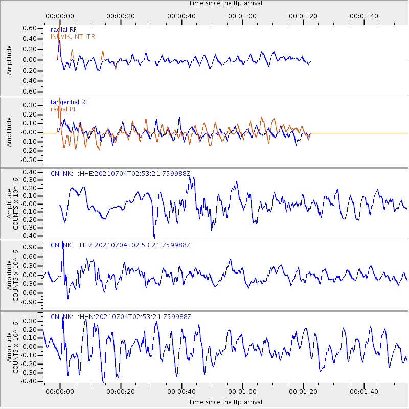
Signal To Noise
| Channel | StoN | STA | LTA |
| CN:INK: :HHZ:20210704T02:53:21.759988Z | 1.9188657 | 4.2471055E-7 | 2.2133416E-7 |
| CN:INK: :HHN:20210704T02:53:21.759988Z | 1.4503938 | 1.572909E-7 | 1.08447026E-7 |
| CN:INK: :HHE:20210704T02:53:21.759988Z | 1.4828995 | 1.7055605E-7 | 1.1501525E-7 |
| Arrivals |
| Ps | |
| PpPs | |
| PsPs/PpSs | |


