You are here: Home > Network List > ET - CERI Southern Appalachian seismic Network Stations List
> Station FPAL Fort Payne,AL > Earthquake Result Viewer
FPAL Fort Payne,AL - Earthquake Result Viewer
| Earthquake location: |
Near Coast Of Peru |
| Earthquake latitude/longitude: |
-15.8/-74.7 |
| Earthquake time(UTC): |
2018/01/14 (014) 09:18:45 GMT |
| Earthquake Depth: |
36 km |
| Earthquake Magnitude: |
7.1 mww |
| Earthquake Catalog/Contributor: |
NEIC PDE/us |
|
| Network: |
ET CERI Southern Appalachian seismic Network |
| Station: |
FPAL Fort Payne,AL |
| Lat/Lon: |
34.54 N/85.61 W |
| Elevation: |
556 m |
|
| Distance: |
51.1 deg |
| Az: |
348.463 deg |
| Baz: |
166.511 deg |
| Ray Param: |
0.06755953 |
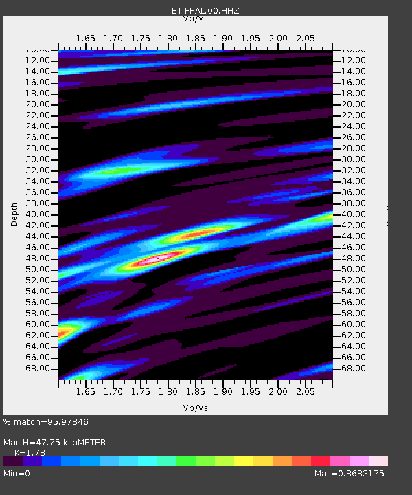
| Estimated Moho Depth: |
47.75 km |
| Estimated Crust Vp/Vs: |
1.78 |
| Assumed Crust Vp: |
6.35 km/s |
| Estimated Crust Vs: |
3.567 km/s |
| Estimated Crust Poisson's Ratio: |
0.27 |
|
| Radial Match: |
95.97846 % |
| Radial Bump: |
372 |
| Transverse Match: |
89.64363 % |
| Transverse Bump: |
400 |
| SOD ConfigId: |
2537391 |
| Insert Time: |
2018-01-28 09:20:00.959 +0000 |
| GWidth: |
2.5 |
| Max Bumps: |
400 |
| Tol: |
0.001 |
|

Signal To Noise
| Channel | StoN | STA | LTA |
| ET:FPAL:00:HHZ:20180114T09:27:13.445Z | 34.90149 | 8.264431E-6 | 2.3679307E-7 |
| ET:FPAL:00:HHN:20180114T09:27:13.445Z | 25.883326 | 3.7155057E-6 | 1.4354823E-7 |
| ET:FPAL:00:HHE:20180114T09:27:13.445Z | 4.3807335 | 7.0919907E-7 | 1.6189048E-7 |
| Arrivals |
| Ps | 6.2 SECOND |
| PpPs | 20 SECOND |
| PsPs/PpSs | 26 SECOND |


