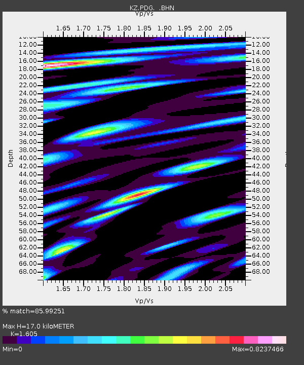
PDG Podgonoye, Kazakstan - Earthquake Result Viewer

Earthquake location: Bonin Islands, Japan Region
Earthquake latitude/longitude: 27.9/141.8
Earthquake time(UTC): 2001/12/23 (357) 10:21:28 GMT
Earthquake Depth: 35 km
Earthquake Magnitude: 5.7 MB, 5.6 MS, 5.9 MW, 5.8 MW
Earthquake Catalog/Contributor: WHDF/NEIC
Network: KZ Kazakhstan Network
Station: PDG Podgonoye, Kazakstan
Lat/Lon: 43.33 N/79.49 E
Elevation: 1277 m
Distance: 51.8 deg
Az: 304.708 deg
Baz: 85.792 deg
Ray Param: 0.06711465
Estimated Moho Depth: 17.0 km
Estimated Crust Vp/Vs: 1.61
Assumed Crust Vp: 6.306 km/s
Estimated Crust Vs: 3.929 km/s
Estimated Crust Poisson's Ratio: 0.18
Radial Match: 85.99251 %
Radial Bump: 400
Transverse Match: 89.71872 %
Transverse Bump: 400
SOD ConfigId: 20082
Insert Time: 2010-03-09 09:58:27.335 +0000
GWidth: 2.5
Max Bumps: 400
Tol: 0.001

Signal To Noise

ChannelStoNSTALTA
KZ:PDG: :BHN:20011223T10:30:01.901001Z2.84598471.15274915E-74.0504403E-8
KZ:PDG: :BHE:20011223T10:30:01.901001Z3.84543737.753793E-82.0163618E-8
KZ:PDG: :BHZ:20011223T10:30:01.901001Z5.1044152.0436663E-74.0037225E-8
Arrivals
Ps1.7 SECOND
PpPs6.6 SECOND
PsPs/PpSs8.3 SECOND