You are here: Home > Network List > G - GEOSCOPE Stations List
> Station IVI Ivittuut, Greenland > Earthquake Result Viewer
IVI Ivittuut, Greenland - Earthquake Result Viewer
| Earthquake location: |
Near Coast Of Peru |
| Earthquake latitude/longitude: |
-15.8/-74.7 |
| Earthquake time(UTC): |
2018/01/14 (014) 09:18:45 GMT |
| Earthquake Depth: |
36 km |
| Earthquake Magnitude: |
7.1 mww |
| Earthquake Catalog/Contributor: |
NEIC PDE/us |
|
| Network: |
G GEOSCOPE |
| Station: |
IVI Ivittuut, Greenland |
| Lat/Lon: |
61.21 N/48.17 W |
| Elevation: |
15 m |
|
| Distance: |
79.6 deg |
| Az: |
12.721 deg |
| Baz: |
205.969 deg |
| Ray Param: |
0.048795994 |
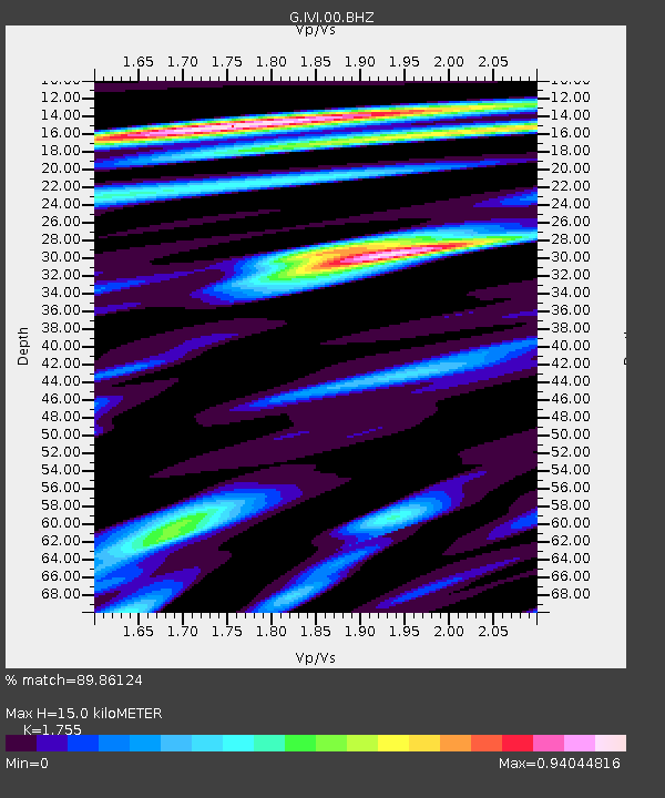
| Estimated Moho Depth: |
15.0 km |
| Estimated Crust Vp/Vs: |
1.75 |
| Assumed Crust Vp: |
6.472 km/s |
| Estimated Crust Vs: |
3.688 km/s |
| Estimated Crust Poisson's Ratio: |
0.26 |
|
| Radial Match: |
89.86124 % |
| Radial Bump: |
400 |
| Transverse Match: |
83.907486 % |
| Transverse Bump: |
400 |
| SOD ConfigId: |
2537391 |
| Insert Time: |
2018-01-28 09:20:10.797 +0000 |
| GWidth: |
2.5 |
| Max Bumps: |
400 |
| Tol: |
0.001 |
|
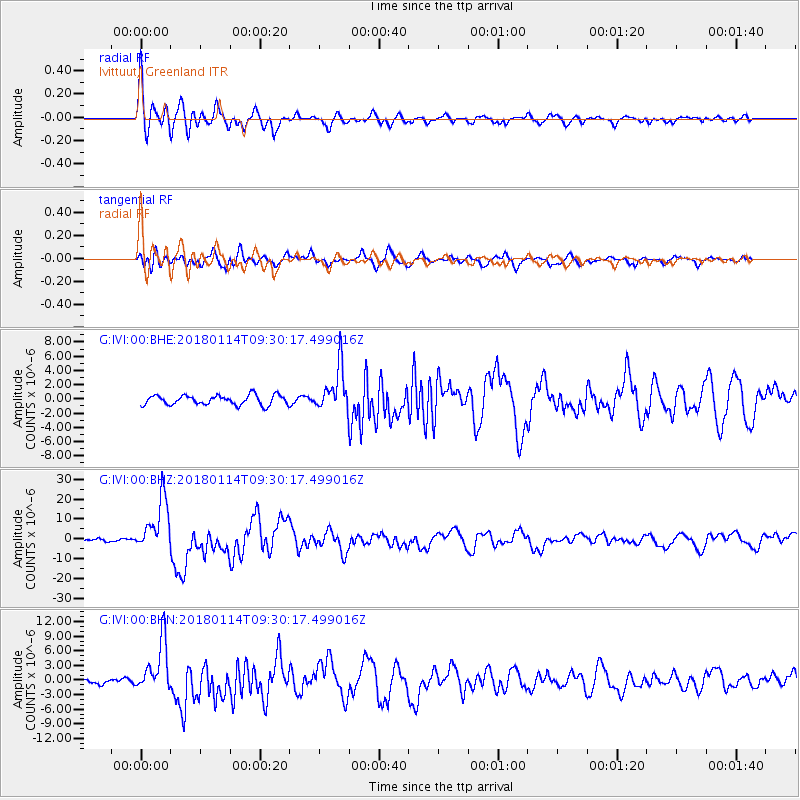
Signal To Noise
| Channel | StoN | STA | LTA |
| G:IVI:00:BHZ:20180114T09:30:17.499016Z | 12.741816 | 1.3339294E-5 | 1.0468912E-6 |
| G:IVI:00:BHN:20180114T09:30:17.499016Z | 7.473534 | 5.3018757E-6 | 7.0942014E-7 |
| G:IVI:00:BHE:20180114T09:30:17.499016Z | 4.4893727 | 3.0555354E-6 | 6.806152E-7 |
| Arrivals |
| Ps | 1.8 SECOND |
| PpPs | 6.2 SECOND |
| PsPs/PpSs | 8.0 SECOND |


