You are here: Home > Network List > G - GEOSCOPE Stations List
> Station TAOE Taiohae, Marquises islands > Earthquake Result Viewer
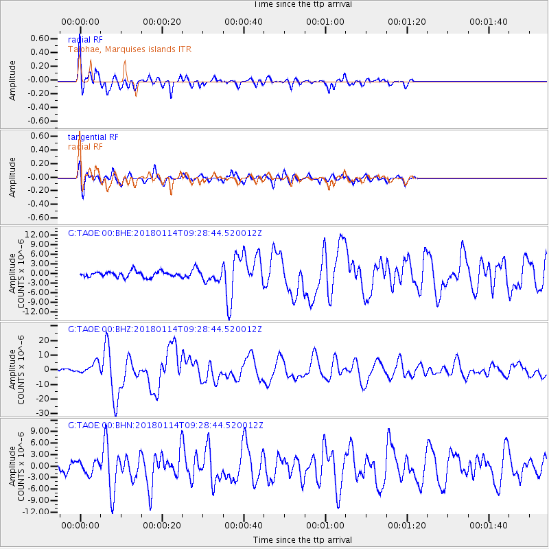
TAOE Taiohae, Marquises islands - Earthquake Result Viewer
*The percent match for this event was below the threshold and hence no stack was calculated.
| Earthquake location: |
Near Coast Of Peru |
| Earthquake latitude/longitude: |
-15.8/-74.7 |
| Earthquake time(UTC): |
2018/01/14 (014) 09:18:45 GMT |
| Earthquake Depth: |
36 km |
| Earthquake Magnitude: |
7.1 mww |
| Earthquake Catalog/Contributor: |
NEIC PDE/us |
|
| Network: |
G GEOSCOPE |
| Station: |
TAOE Taiohae, Marquises islands |
| Lat/Lon: |
8.85 S/140.15 W |
| Elevation: |
800 m |
|
| Distance: |
64.1 deg |
| Az: |
267.699 deg |
| Baz: |
103.224 deg |
| Ray Param: |
$rayparam |
*The percent match for this event was below the threshold and hence was not used in the summary stack. |
|
| Radial Match: |
79.01766 % |
| Radial Bump: |
400 |
| Transverse Match: |
78.89737 % |
| Transverse Bump: |
400 |
| SOD ConfigId: |
2537391 |
| Insert Time: |
2018-01-28 09:20:17.822 +0000 |
| GWidth: |
2.5 |
| Max Bumps: |
400 |
| Tol: |
0.001 |
|
Signal To Noise
| Channel | StoN | STA | LTA |
| G:TAOE:00:BHZ:20180114T09:28:44.520012Z | 2.9103594 | 3.8935777E-6 | 1.3378341E-6 |
| G:TAOE:00:BHN:20180114T09:28:44.520012Z | 1.6152406 | 1.686974E-6 | 1.0444103E-6 |
| G:TAOE:00:BHE:20180114T09:28:44.520012Z | 1.9870712 | 1.7368632E-6 | 8.7408205E-7 |
| Arrivals |
| Ps | |
| PpPs | |
| PsPs/PpSs | |


