You are here: Home > Network List > KZ - Kazakhstan Network Stations List
> Station PDG Podgonoye, Kazakstan > Earthquake Result Viewer
PDG Podgonoye, Kazakstan - Earthquake Result Viewer
| Earthquake location: |
Banda Sea |
| Earthquake latitude/longitude: |
-7.5/127.7 |
| Earthquake time(UTC): |
2001/09/18 (261) 02:19:30 GMT |
| Earthquake Depth: |
132 km |
| Earthquake Magnitude: |
5.6 MB, 5.1 MS, 6.0 MW, 6.0 MW |
| Earthquake Catalog/Contributor: |
WHDF/NEIC |
|
| Network: |
KZ Kazakhstan Network |
| Station: |
PDG Podgonoye, Kazakstan |
| Lat/Lon: |
43.33 N/79.49 E |
| Elevation: |
1277 m |
|
| Distance: |
66.9 deg |
| Az: |
323.693 deg |
| Baz: |
126.434 deg |
| Ray Param: |
0.05697818 |
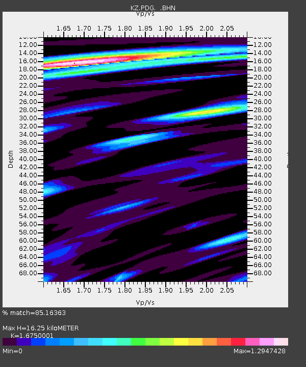
| Estimated Moho Depth: |
16.25 km |
| Estimated Crust Vp/Vs: |
1.68 |
| Assumed Crust Vp: |
6.306 km/s |
| Estimated Crust Vs: |
3.765 km/s |
| Estimated Crust Poisson's Ratio: |
0.22 |
|
| Radial Match: |
85.16363 % |
| Radial Bump: |
400 |
| Transverse Match: |
89.02134 % |
| Transverse Bump: |
400 |
| SOD ConfigId: |
20082 |
| Insert Time: |
2010-03-09 09:58:40.152 +0000 |
| GWidth: |
2.5 |
| Max Bumps: |
400 |
| Tol: |
0.001 |
|

Signal To Noise
| Channel | StoN | STA | LTA |
| KZ:PDG: :BHN:20010918T02:29:37.748008Z | 0.8991143 | 2.1941604E-8 | 2.4403576E-8 |
| KZ:PDG: :BHE:20010918T02:29:37.748008Z | 3.6201408 | 3.7799044E-8 | 1.0441319E-8 |
| KZ:PDG: :BHZ:20010918T02:29:37.748008Z | 4.2006254 | 1.3731012E-7 | 3.268802E-8 |
| Arrivals |
| Ps | 1.8 SECOND |
| PpPs | 6.6 SECOND |
| PsPs/PpSs | 8.4 SECOND |


