You are here: Home > Network List > KZ - Kazakhstan Network Stations List
> Station PDG Podgonoye, Kazakstan > Earthquake Result Viewer
PDG Podgonoye, Kazakstan - Earthquake Result Viewer
| Earthquake location: |
Hokkaido, Japan Region |
| Earthquake latitude/longitude: |
41.0/142.3 |
| Earthquake time(UTC): |
2001/08/13 (225) 20:11:23 GMT |
| Earthquake Depth: |
38 km |
| Earthquake Magnitude: |
6.0 MB, 6.3 MS, 6.4 MW, 6.3 ME |
| Earthquake Catalog/Contributor: |
WHDF/NEIC |
|
| Network: |
KZ Kazakhstan Network |
| Station: |
PDG Podgonoye, Kazakstan |
| Lat/Lon: |
43.33 N/79.49 E |
| Elevation: |
1277 m |
|
| Distance: |
45.6 deg |
| Az: |
294.738 deg |
| Baz: |
70.282 deg |
| Ray Param: |
0.07106863 |
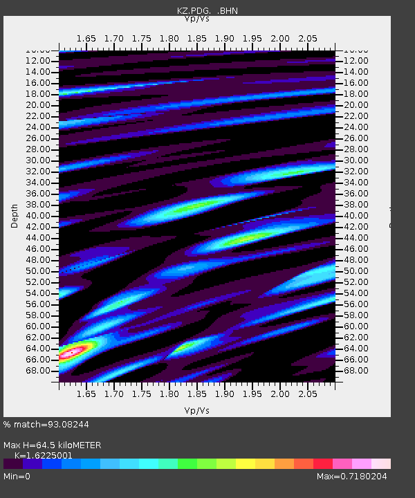
| Estimated Moho Depth: |
64.5 km |
| Estimated Crust Vp/Vs: |
1.62 |
| Assumed Crust Vp: |
6.306 km/s |
| Estimated Crust Vs: |
3.887 km/s |
| Estimated Crust Poisson's Ratio: |
0.19 |
|
| Radial Match: |
93.08244 % |
| Radial Bump: |
400 |
| Transverse Match: |
92.42998 % |
| Transverse Bump: |
400 |
| SOD ConfigId: |
20082 |
| Insert Time: |
2010-03-09 09:58:48.505 +0000 |
| GWidth: |
2.5 |
| Max Bumps: |
400 |
| Tol: |
0.001 |
|

Signal To Noise
| Channel | StoN | STA | LTA |
| KZ:PDG: :BHN:20010813T20:19:09.54801Z | 27.384047 | 7.5264694E-7 | 2.748487E-8 |
| KZ:PDG: :BHE:20010813T20:19:09.54801Z | 51.22291 | 5.763461E-7 | 1.1251726E-8 |
| KZ:PDG: :BHZ:20010813T20:19:09.54801Z | 34.860577 | 1.6170342E-6 | 4.6385754E-8 |
| Arrivals |
| Ps | 6.8 SECOND |
| PpPs | 25 SECOND |
| PsPs/PpSs | 32 SECOND |


