You are here: Home > Network List > GM - US Geological Survey Networks Stations List
> Station IWM01 Jericho 2M Well Monitoring Station > Earthquake Result Viewer
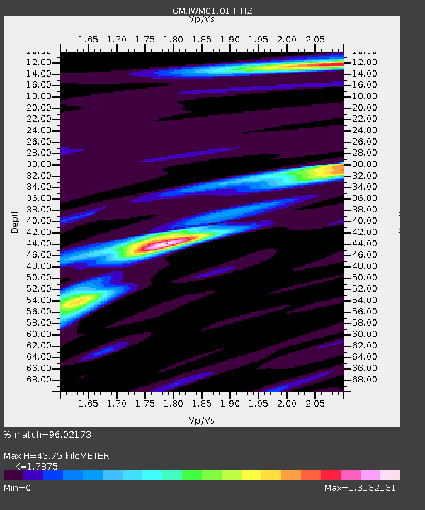
IWM01 Jericho 2M Well Monitoring Station - Earthquake Result Viewer
| Earthquake location: |
Near Coast Of Peru |
| Earthquake latitude/longitude: |
-15.8/-74.7 |
| Earthquake time(UTC): |
2018/01/14 (014) 09:18:45 GMT |
| Earthquake Depth: |
36 km |
| Earthquake Magnitude: |
7.1 mww |
| Earthquake Catalog/Contributor: |
NEIC PDE/us |
|
| Network: |
GM US Geological Survey Networks |
| Station: |
IWM01 Jericho 2M Well Monitoring Station |
| Lat/Lon: |
36.73 N/96.53 W |
| Elevation: |
328 m |
|
| Distance: |
56.1 deg |
| Az: |
338.951 deg |
| Baz: |
154.505 deg |
| Ray Param: |
0.06427769 |
| Estimated Moho Depth: |
43.75 km |
| Estimated Crust Vp/Vs: |
1.79 |
| Assumed Crust Vp: |
6.483 km/s |
| Estimated Crust Vs: |
3.627 km/s |
| Estimated Crust Poisson's Ratio: |
0.27 |
|
| Radial Match: |
96.02173 % |
| Radial Bump: |
284 |
| Transverse Match: |
81.21464 % |
| Transverse Bump: |
400 |
| SOD ConfigId: |
2537391 |
| Insert Time: |
2018-01-28 09:20:34.422 +0000 |
| GWidth: |
2.5 |
| Max Bumps: |
400 |
| Tol: |
0.001 |
|

Signal To Noise
| Channel | StoN | STA | LTA |
| GM:IWM01:01:HHZ:20180114T09:27:50.21502Z | 71.83273 | 2.199136E-5 | 3.061468E-7 |
| GM:IWM01:01:HHN:20180114T09:27:50.21502Z | 49.937035 | 1.0424619E-5 | 2.0875527E-7 |
| GM:IWM01:01:HHE:20180114T09:27:50.21502Z | 28.170906 | 7.0502983E-6 | 2.5026878E-7 |
| Arrivals |
| Ps | 5.6 SECOND |
| PpPs | 18 SECOND |
| PsPs/PpSs | 23 SECOND |


