You are here: Home > Network List > KZ - Kazakhstan Network Stations List
> Station PDG Podgonoye, Kazakstan > Earthquake Result Viewer
PDG Podgonoye, Kazakstan - Earthquake Result Viewer
| Earthquake location: |
Southeast Of Honshu, Japan |
| Earthquake latitude/longitude: |
29.3/139.0 |
| Earthquake time(UTC): |
2002/08/02 (214) 23:11:39 GMT |
| Earthquake Depth: |
426 km |
| Earthquake Magnitude: |
5.5 MB, 6.3 MW, 6.3 MW |
| Earthquake Catalog/Contributor: |
WHDF/NEIC |
|
| Network: |
KZ Kazakhstan Network |
| Station: |
PDG Podgonoye, Kazakstan |
| Lat/Lon: |
43.33 N/79.49 E |
| Elevation: |
1277 m |
|
| Distance: |
49.0 deg |
| Az: |
303.559 deg |
| Baz: |
86.065 deg |
| Ray Param: |
0.067201495 |
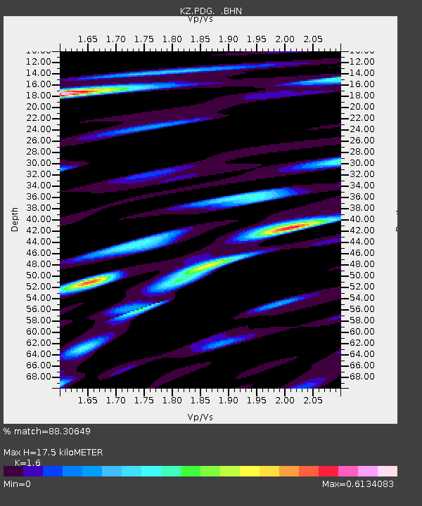
| Estimated Moho Depth: |
17.5 km |
| Estimated Crust Vp/Vs: |
1.60 |
| Assumed Crust Vp: |
6.306 km/s |
| Estimated Crust Vs: |
3.941 km/s |
| Estimated Crust Poisson's Ratio: |
0.18 |
|
| Radial Match: |
88.30649 % |
| Radial Bump: |
400 |
| Transverse Match: |
87.94922 % |
| Transverse Bump: |
400 |
| SOD ConfigId: |
20082 |
| Insert Time: |
2010-03-09 09:59:19.767 +0000 |
| GWidth: |
2.5 |
| Max Bumps: |
400 |
| Tol: |
0.001 |
|

Signal To Noise
| Channel | StoN | STA | LTA |
| KZ:PDG: :BHN:20020802T23:19:14.295009Z | 22.43265 | 4.0332264E-7 | 1.797927E-8 |
| KZ:PDG: :BHE:20020802T23:19:14.295009Z | 30.75952 | 5.5730266E-7 | 1.8118055E-8 |
| KZ:PDG: :BHZ:20020802T23:19:14.295009Z | 49.339718 | 1.5565291E-6 | 3.154718E-8 |
| Arrivals |
| Ps | 1.8 SECOND |
| PpPs | 6.8 SECOND |
| PsPs/PpSs | 8.6 SECOND |


