You are here: Home > Network List > KZ - Kazakhstan Network Stations List
> Station PDG Podgonoye, Kazakstan > Earthquake Result Viewer
PDG Podgonoye, Kazakstan - Earthquake Result Viewer
| Earthquake location: |
Minahassa Peninsula, Sulawesi |
| Earthquake latitude/longitude: |
0.7/122.3 |
| Earthquake time(UTC): |
2002/03/17 (076) 03:37:19 GMT |
| Earthquake Depth: |
79 km |
| Earthquake Magnitude: |
5.6 MB, 5.8 MW, 5.7 MW |
| Earthquake Catalog/Contributor: |
WHDF/NEIC |
|
| Network: |
KZ Kazakhstan Network |
| Station: |
PDG Podgonoye, Kazakstan |
| Lat/Lon: |
43.33 N/79.49 E |
| Elevation: |
1277 m |
|
| Distance: |
57.1 deg |
| Az: |
323.779 deg |
| Baz: |
125.935 deg |
| Ray Param: |
0.06348862 |
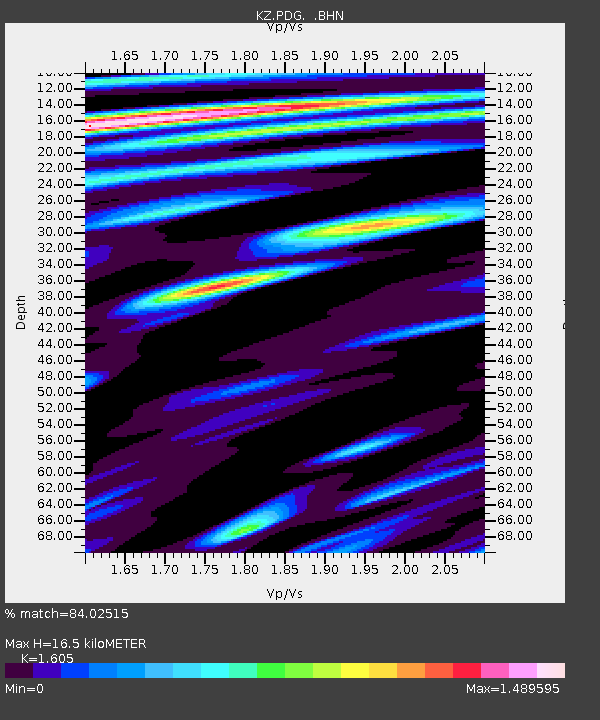
| Estimated Moho Depth: |
16.5 km |
| Estimated Crust Vp/Vs: |
1.61 |
| Assumed Crust Vp: |
6.306 km/s |
| Estimated Crust Vs: |
3.929 km/s |
| Estimated Crust Poisson's Ratio: |
0.18 |
|
| Radial Match: |
84.02515 % |
| Radial Bump: |
400 |
| Transverse Match: |
87.000946 % |
| Transverse Bump: |
400 |
| SOD ConfigId: |
20082 |
| Insert Time: |
2010-03-09 09:59:30.335 +0000 |
| GWidth: |
2.5 |
| Max Bumps: |
400 |
| Tol: |
0.001 |
|

Signal To Noise
| Channel | StoN | STA | LTA |
| KZ:PDG: :BHN:20020317T03:46:27.458005Z | 1.5498123 | 6.026246E-8 | 3.8883716E-8 |
| KZ:PDG: :BHE:20020317T03:46:27.458005Z | 2.5952187 | 3.458094E-8 | 1.3324866E-8 |
| KZ:PDG: :BHZ:20020317T03:46:27.458005Z | 4.146668 | 1.2306192E-7 | 2.96773E-8 |
| Arrivals |
| Ps | 1.7 SECOND |
| PpPs | 6.5 SECOND |
| PsPs/PpSs | 8.1 SECOND |


