You are here: Home > Network List > GS - US Geological Survey Networks Stations List
> Station KAN05 Bluff City North Station > Earthquake Result Viewer
KAN05 Bluff City North Station - Earthquake Result Viewer
| Earthquake location: |
Near Coast Of Peru |
| Earthquake latitude/longitude: |
-15.8/-74.7 |
| Earthquake time(UTC): |
2018/01/14 (014) 09:18:45 GMT |
| Earthquake Depth: |
36 km |
| Earthquake Magnitude: |
7.1 mww |
| Earthquake Catalog/Contributor: |
NEIC PDE/us |
|
| Network: |
GS US Geological Survey Networks |
| Station: |
KAN05 Bluff City North Station |
| Lat/Lon: |
37.11 N/97.87 W |
| Elevation: |
348 m |
|
| Distance: |
56.9 deg |
| Az: |
337.996 deg |
| Baz: |
153.177 deg |
| Ray Param: |
0.0637444 |
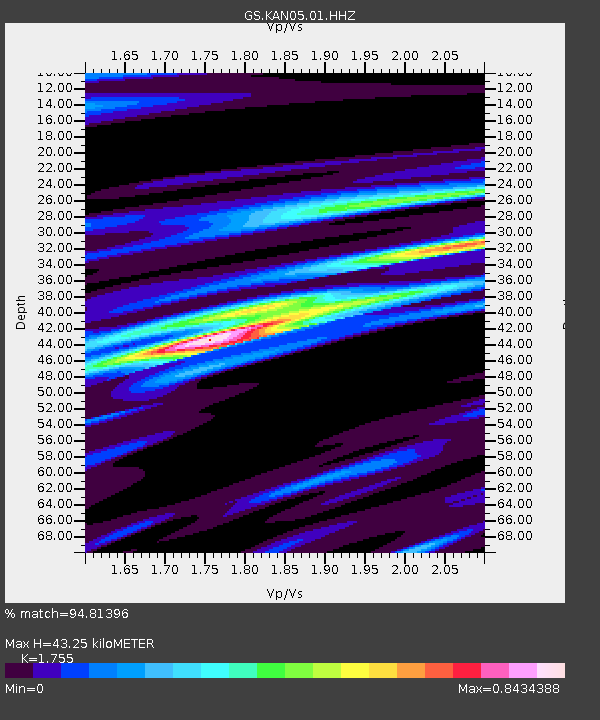
| Estimated Moho Depth: |
43.25 km |
| Estimated Crust Vp/Vs: |
1.75 |
| Assumed Crust Vp: |
6.483 km/s |
| Estimated Crust Vs: |
3.694 km/s |
| Estimated Crust Poisson's Ratio: |
0.26 |
|
| Radial Match: |
94.81396 % |
| Radial Bump: |
262 |
| Transverse Match: |
72.4498 % |
| Transverse Bump: |
400 |
| SOD ConfigId: |
2537391 |
| Insert Time: |
2018-01-28 09:20:49.471 +0000 |
| GWidth: |
2.5 |
| Max Bumps: |
400 |
| Tol: |
0.001 |
|

Signal To Noise
| Channel | StoN | STA | LTA |
| GS:KAN05:01:HHZ:20180114T09:27:55.999993Z | 43.180977 | 1.9788053E-5 | 4.5825854E-7 |
| GS:KAN05:01:HHN:20180114T09:27:55.999993Z | 22.215263 | 1.0224283E-5 | 4.602369E-7 |
| GS:KAN05:01:HHE:20180114T09:27:55.999993Z | 6.6390114 | 3.4055108E-6 | 5.129545E-7 |
| Arrivals |
| Ps | 5.3 SECOND |
| PpPs | 17 SECOND |
| PsPs/PpSs | 23 SECOND |


