You are here: Home > Network List > GS - US Geological Survey Networks Stations List
> Station KAN06 Argonia West Station > Earthquake Result Viewer
KAN06 Argonia West Station - Earthquake Result Viewer
| Earthquake location: |
Near Coast Of Peru |
| Earthquake latitude/longitude: |
-15.8/-74.7 |
| Earthquake time(UTC): |
2018/01/14 (014) 09:18:45 GMT |
| Earthquake Depth: |
36 km |
| Earthquake Magnitude: |
7.1 mww |
| Earthquake Catalog/Contributor: |
NEIC PDE/us |
|
| Network: |
GS US Geological Survey Networks |
| Station: |
KAN06 Argonia West Station |
| Lat/Lon: |
37.25 N/97.86 W |
| Elevation: |
393 m |
|
| Distance: |
57.1 deg |
| Az: |
338.082 deg |
| Baz: |
153.232 deg |
| Ray Param: |
0.063666135 |
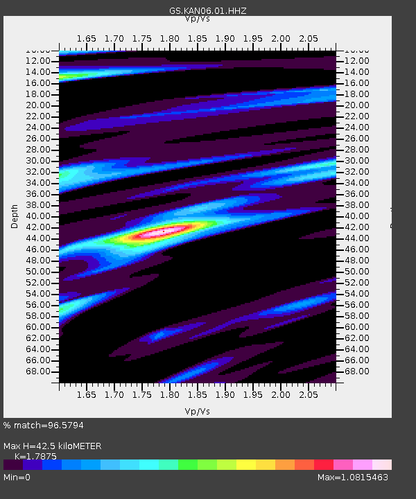
| Estimated Moho Depth: |
42.5 km |
| Estimated Crust Vp/Vs: |
1.79 |
| Assumed Crust Vp: |
6.483 km/s |
| Estimated Crust Vs: |
3.627 km/s |
| Estimated Crust Poisson's Ratio: |
0.27 |
|
| Radial Match: |
96.5794 % |
| Radial Bump: |
261 |
| Transverse Match: |
76.25403 % |
| Transverse Bump: |
400 |
| SOD ConfigId: |
2537391 |
| Insert Time: |
2018-01-28 09:20:52.113 +0000 |
| GWidth: |
2.5 |
| Max Bumps: |
400 |
| Tol: |
0.001 |
|

Signal To Noise
| Channel | StoN | STA | LTA |
| GS:KAN06:01:HHZ:20180114T09:27:56.845024Z | 93.30074 | 2.1046675E-5 | 2.2557886E-7 |
| GS:KAN06:01:HHN:20180114T09:27:56.845024Z | 39.91772 | 9.989852E-6 | 2.5026108E-7 |
| GS:KAN06:01:HHE:20180114T09:27:56.845024Z | 16.704805 | 4.4093044E-6 | 2.6395426E-7 |
| Arrivals |
| Ps | 5.4 SECOND |
| PpPs | 17 SECOND |
| PsPs/PpSs | 23 SECOND |


