You are here: Home > Network List > GS - US Geological Survey Networks Stations List
> Station KAN09 Caldwell North Station > Earthquake Result Viewer
KAN09 Caldwell North Station - Earthquake Result Viewer

| Earthquake location: |
Near Coast Of Peru |
| Earthquake latitude/longitude: |
-15.8/-74.7 |
| Earthquake time(UTC): |
2018/01/14 (014) 09:18:45 GMT |
| Earthquake Depth: |
36 km |
| Earthquake Magnitude: |
7.1 mww |
| Earthquake Catalog/Contributor: |
NEIC PDE/us |
|
| Network: |
GS US Geological Survey Networks |
| Station: |
KAN09 Caldwell North Station |
| Lat/Lon: |
37.14 N/97.62 W |
| Elevation: |
371 m |
|
| Distance: |
56.9 deg |
| Az: |
338.227 deg |
| Baz: |
153.456 deg |
| Ray Param: |
0.063788146 |
| Estimated Moho Depth: |
43.75 km |
| Estimated Crust Vp/Vs: |
1.80 |
| Assumed Crust Vp: |
6.483 km/s |
| Estimated Crust Vs: |
3.601 km/s |
| Estimated Crust Poisson's Ratio: |
0.28 |
|
| Radial Match: |
86.88463 % |
| Radial Bump: |
314 |
| Transverse Match: |
54.168293 % |
| Transverse Bump: |
400 |
| SOD ConfigId: |
2537391 |
| Insert Time: |
2018-01-28 09:20:55.098 +0000 |
| GWidth: |
2.5 |
| Max Bumps: |
400 |
| Tol: |
0.001 |
|
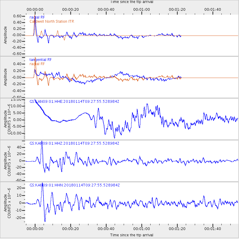
Signal To Noise
| Channel | StoN | STA | LTA |
| GS:KAN09:01:HHZ:20180114T09:27:55.528984Z | 80.110054 | 2.0682495E-5 | 2.5817602E-7 |
| GS:KAN09:01:HHN:20180114T09:27:55.528984Z | 19.169453 | 1.0052745E-5 | 5.244148E-7 |
| GS:KAN09:01:HHE:20180114T09:27:55.528984Z | 0.73710823 | 3.2717917E-6 | 4.4386857E-6 |
| Arrivals |
| Ps | 5.7 SECOND |
| PpPs | 18 SECOND |
| PsPs/PpSs | 24 SECOND |


