You are here: Home > Network List > KZ - Kazakhstan Network Stations List
> Station PDG Podgonoye, Kazakstan > Earthquake Result Viewer
PDG Podgonoye, Kazakstan - Earthquake Result Viewer
| Earthquake location: |
Halmahera, Indonesia |
| Earthquake latitude/longitude: |
1.7/127.3 |
| Earthquake time(UTC): |
2003/03/10 (069) 02:09:37 GMT |
| Earthquake Depth: |
94 km |
| Earthquake Magnitude: |
6.2 MB, 6.4 MW, 6.4 MW |
| Earthquake Catalog/Contributor: |
WHDF/NEIC |
|
| Network: |
KZ Kazakhstan Network |
| Station: |
PDG Podgonoye, Kazakstan |
| Lat/Lon: |
43.33 N/79.49 E |
| Elevation: |
1277 m |
|
| Distance: |
59.3 deg |
| Az: |
321.057 deg |
| Baz: |
120.576 deg |
| Ray Param: |
0.061984714 |
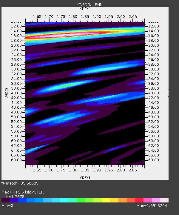
| Estimated Moho Depth: |
15.5 km |
| Estimated Crust Vp/Vs: |
1.77 |
| Assumed Crust Vp: |
6.306 km/s |
| Estimated Crust Vs: |
3.568 km/s |
| Estimated Crust Poisson's Ratio: |
0.26 |
|
| Radial Match: |
85.50605 % |
| Radial Bump: |
400 |
| Transverse Match: |
94.13079 % |
| Transverse Bump: |
400 |
| SOD ConfigId: |
4714 |
| Insert Time: |
2010-03-09 09:59:46.788 +0000 |
| GWidth: |
2.5 |
| Max Bumps: |
400 |
| Tol: |
0.001 |
|

Signal To Noise
| Channel | StoN | STA | LTA |
| KZ:PDG: :BHN:20030310T02:18:58.645002Z | 2.9437194 | 1.0204301E-7 | 3.4664655E-8 |
| KZ:PDG: :BHE:20030310T02:18:58.645002Z | 7.431372 | 1.9019733E-7 | 2.5593838E-8 |
| KZ:PDG: :BHZ:20030310T02:18:58.645002Z | 12.952486 | 7.0058155E-7 | 5.4088577E-8 |
| Arrivals |
| Ps | 2.0 SECOND |
| PpPs | 6.5 SECOND |
| PsPs/PpSs | 8.5 SECOND |


