You are here: Home > Network List > NM - Cooperative New Madrid Seismic Network Stations List
> Station HDAR2 I40 Weigh Station,West Memphis,AR > Earthquake Result Viewer
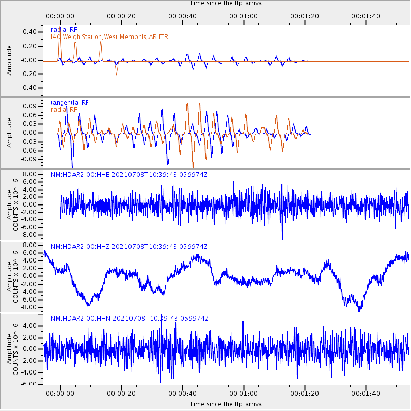
HDAR2 I40 Weigh Station,West Memphis,AR - Earthquake Result Viewer
*The percent match for this event was below the threshold and hence no stack was calculated.
| Earthquake location: |
Off Coast Of Northern Chile |
| Earthquake latitude/longitude: |
-18.5/-71.2 |
| Earthquake time(UTC): |
2021/07/08 (189) 10:30:38 GMT |
| Earthquake Depth: |
55 km |
| Earthquake Magnitude: |
5.2 Mww |
| Earthquake Catalog/Contributor: |
NEIC PDE/us |
|
| Network: |
NM Cooperative New Madrid Seismic Network |
| Station: |
HDAR2 I40 Weigh Station,West Memphis,AR |
| Lat/Lon: |
35.15 N/90.09 W |
| Elevation: |
100 m |
|
| Distance: |
56.2 deg |
| Az: |
341.421 deg |
| Baz: |
158.343 deg |
| Ray Param: |
$rayparam |
*The percent match for this event was below the threshold and hence was not used in the summary stack. |
|
| Radial Match: |
32.182896 % |
| Radial Bump: |
400 |
| Transverse Match: |
45.280876 % |
| Transverse Bump: |
400 |
| SOD ConfigId: |
25131211 |
| Insert Time: |
2021-07-22 10:39:53.688 +0000 |
| GWidth: |
2.5 |
| Max Bumps: |
400 |
| Tol: |
0.001 |
|
Signal To Noise
| Channel | StoN | STA | LTA |
| NM:HDAR2:00:HHZ:20210708T10:39:43.059974Z | 0.45878202 | 1.6806086E-6 | 3.6631964E-6 |
| NM:HDAR2:00:HHN:20210708T10:39:43.059974Z | 0.80868345 | 1.176358E-6 | 1.4546581E-6 |
| NM:HDAR2:00:HHE:20210708T10:39:43.059974Z | 1.2124109 | 1.94959E-6 | 1.6080273E-6 |
| Arrivals |
| Ps | |
| PpPs | |
| PsPs/PpSs | |


