You are here: Home > Network List > KZ - Kazakhstan Network Stations List
> Station TLG Talgar, Kazakstan > Earthquake Result Viewer
TLG Talgar, Kazakstan - Earthquake Result Viewer
| Earthquake location: |
Kuril Islands |
| Earthquake latitude/longitude: |
43.6/147.1 |
| Earthquake time(UTC): |
1994/10/18 (291) 17:12:51 GMT |
| Earthquake Depth: |
66 km |
| Earthquake Magnitude: |
6.1 MB, 6.1 UNKNOWN, 5.9 MW |
| Earthquake Catalog/Contributor: |
WHDF/NEIC |
|
| Network: |
KZ Kazakhstan Network |
| Station: |
TLG Talgar, Kazakstan |
| Lat/Lon: |
43.23 N/77.22 E |
| Elevation: |
1120 m |
|
| Distance: |
49.4 deg |
| Az: |
295.254 deg |
| Baz: |
64.118 deg |
| Ray Param: |
0.0685591 |
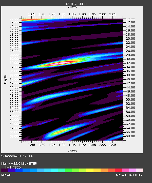
| Estimated Moho Depth: |
32.0 km |
| Estimated Crust Vp/Vs: |
1.78 |
| Assumed Crust Vp: |
6.306 km/s |
| Estimated Crust Vs: |
3.538 km/s |
| Estimated Crust Poisson's Ratio: |
0.27 |
|
| Radial Match: |
91.62044 % |
| Radial Bump: |
400 |
| Transverse Match: |
84.09991 % |
| Transverse Bump: |
400 |
| SOD ConfigId: |
17000 |
| Insert Time: |
2010-03-09 09:59:58.109 +0000 |
| GWidth: |
2.5 |
| Max Bumps: |
400 |
| Tol: |
0.001 |
|

Signal To Noise
| Channel | StoN | STA | LTA |
| KZ:TLG: :BHN:19941018T17:21:03.695013Z | 4.99987 | 3.6590126E-7 | 7.318216E-8 |
| KZ:TLG: :BHE:19941018T17:21:03.695013Z | 17.130762 | 1.4826601E-6 | 8.654957E-8 |
| KZ:TLG: :BHZ:19941018T17:21:03.695013Z | 54.054302 | 4.128618E-6 | 7.637908E-8 |
| Arrivals |
| Ps | 4.2 SECOND |
| PpPs | 13 SECOND |
| PsPs/PpSs | 18 SECOND |


