You are here: Home > Network List > IU - Global Seismograph Network (GSN - IRIS/USGS) Stations List
> Station CCM Cathedral Cave, Missouri, USA > Earthquake Result Viewer
CCM Cathedral Cave, Missouri, USA - Earthquake Result Viewer
| Earthquake location: |
Near Coast Of Peru |
| Earthquake latitude/longitude: |
-15.8/-74.7 |
| Earthquake time(UTC): |
2018/01/14 (014) 09:18:45 GMT |
| Earthquake Depth: |
36 km |
| Earthquake Magnitude: |
7.1 mww |
| Earthquake Catalog/Contributor: |
NEIC PDE/us |
|
| Network: |
IU Global Seismograph Network (GSN - IRIS/USGS) |
| Station: |
CCM Cathedral Cave, Missouri, USA |
| Lat/Lon: |
38.06 N/91.24 W |
| Elevation: |
222 m |
|
| Distance: |
55.7 deg |
| Az: |
344.26 deg |
| Baz: |
160.679 deg |
| Ray Param: |
0.064524986 |
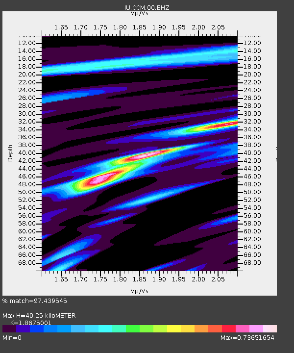
| Estimated Moho Depth: |
40.25 km |
| Estimated Crust Vp/Vs: |
1.87 |
| Assumed Crust Vp: |
6.498 km/s |
| Estimated Crust Vs: |
3.479 km/s |
| Estimated Crust Poisson's Ratio: |
0.30 |
|
| Radial Match: |
97.439545 % |
| Radial Bump: |
301 |
| Transverse Match: |
89.86927 % |
| Transverse Bump: |
400 |
| SOD ConfigId: |
2537391 |
| Insert Time: |
2018-01-28 09:21:32.843 +0000 |
| GWidth: |
2.5 |
| Max Bumps: |
400 |
| Tol: |
0.001 |
|
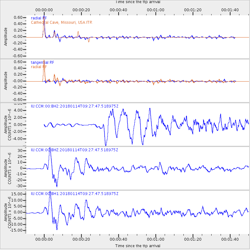
Signal To Noise
| Channel | StoN | STA | LTA |
| IU:CCM:00:BHZ:20180114T09:27:47.518975Z | 54.344395 | 1.5067094E-5 | 2.7725204E-7 |
| IU:CCM:00:BH1:20180114T09:27:47.518975Z | 25.605017 | 7.404143E-6 | 2.8916767E-7 |
| IU:CCM:00:BH2:20180114T09:27:47.518975Z | 9.752781 | 2.717643E-6 | 2.7865312E-7 |
| Arrivals |
| Ps | 5.6 SECOND |
| PpPs | 17 SECOND |
| PsPs/PpSs | 23 SECOND |


