You are here: Home > Network List > KZ - Kazakhstan Network Stations List
> Station TLG Talgar, Kazakstan > Earthquake Result Viewer
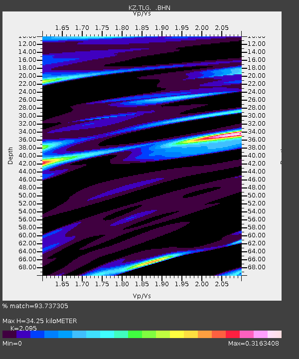
TLG Talgar, Kazakstan - Earthquake Result Viewer
| Earthquake location: |
Samar, Philippines |
| Earthquake latitude/longitude: |
12.1/125.9 |
| Earthquake time(UTC): |
1995/04/21 (111) 05:17:00 GMT |
| Earthquake Depth: |
23 km |
| Earthquake Magnitude: |
5.6 MB, 6.9 MS, 6.7 UNKNOWN, 6.7 MW |
| Earthquake Catalog/Contributor: |
WHDF/NEIC |
|
| Network: |
KZ Kazakhstan Network |
| Station: |
TLG Talgar, Kazakstan |
| Lat/Lon: |
43.23 N/77.22 E |
| Elevation: |
1120 m |
|
| Distance: |
52.1 deg |
| Az: |
315.894 deg |
| Baz: |
111.37 deg |
| Ray Param: |
0.066936396 |
| Estimated Moho Depth: |
34.25 km |
| Estimated Crust Vp/Vs: |
2.10 |
| Assumed Crust Vp: |
6.306 km/s |
| Estimated Crust Vs: |
3.01 km/s |
| Estimated Crust Poisson's Ratio: |
0.35 |
|
| Radial Match: |
93.737305 % |
| Radial Bump: |
400 |
| Transverse Match: |
85.714035 % |
| Transverse Bump: |
400 |
| SOD ConfigId: |
6273 |
| Insert Time: |
2010-03-09 10:00:40.717 +0000 |
| GWidth: |
2.5 |
| Max Bumps: |
400 |
| Tol: |
0.001 |
|

Signal To Noise
| Channel | StoN | STA | LTA |
| KZ:TLG: :BHN:19950421T05:25:38.195996Z | 2.3295662 | 2.2424425E-7 | 9.626008E-8 |
| KZ:TLG: :BHE:19950421T05:25:38.195996Z | 2.6711924 | 1.5177298E-7 | 5.681844E-8 |
| KZ:TLG: :BHZ:19950421T05:25:38.195996Z | 5.8685603 | 4.486867E-7 | 7.645601E-8 |
| Arrivals |
| Ps | 6.2 SECOND |
| PpPs | 16 SECOND |
| PsPs/PpSs | 22 SECOND |


