You are here: Home > Network List > IU - Global Seismograph Network (GSN - IRIS/USGS) Stations List
> Station SFJD Sondre Stromfjord, Greenland > Earthquake Result Viewer
SFJD Sondre Stromfjord, Greenland - Earthquake Result Viewer
| Earthquake location: |
Near Coast Of Peru |
| Earthquake latitude/longitude: |
-15.8/-74.7 |
| Earthquake time(UTC): |
2018/01/14 (014) 09:18:45 GMT |
| Earthquake Depth: |
36 km |
| Earthquake Magnitude: |
7.1 mww |
| Earthquake Catalog/Contributor: |
NEIC PDE/us |
|
| Network: |
IU Global Seismograph Network (GSN - IRIS/USGS) |
| Station: |
SFJD Sondre Stromfjord, Greenland |
| Lat/Lon: |
67.00 N/50.62 W |
| Elevation: |
330 m |
|
| Distance: |
84.4 deg |
| Az: |
9.288 deg |
| Baz: |
203.289 deg |
| Ray Param: |
0.045431554 |
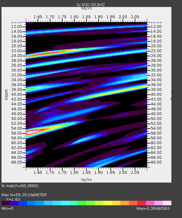
| Estimated Moho Depth: |
55.25 km |
| Estimated Crust Vp/Vs: |
1.63 |
| Assumed Crust Vp: |
6.459 km/s |
| Estimated Crust Vs: |
3.963 km/s |
| Estimated Crust Poisson's Ratio: |
0.20 |
|
| Radial Match: |
88.39981 % |
| Radial Bump: |
400 |
| Transverse Match: |
47.427086 % |
| Transverse Bump: |
400 |
| SOD ConfigId: |
2537391 |
| Insert Time: |
2018-01-28 09:21:51.293 +0000 |
| GWidth: |
2.5 |
| Max Bumps: |
400 |
| Tol: |
0.001 |
|
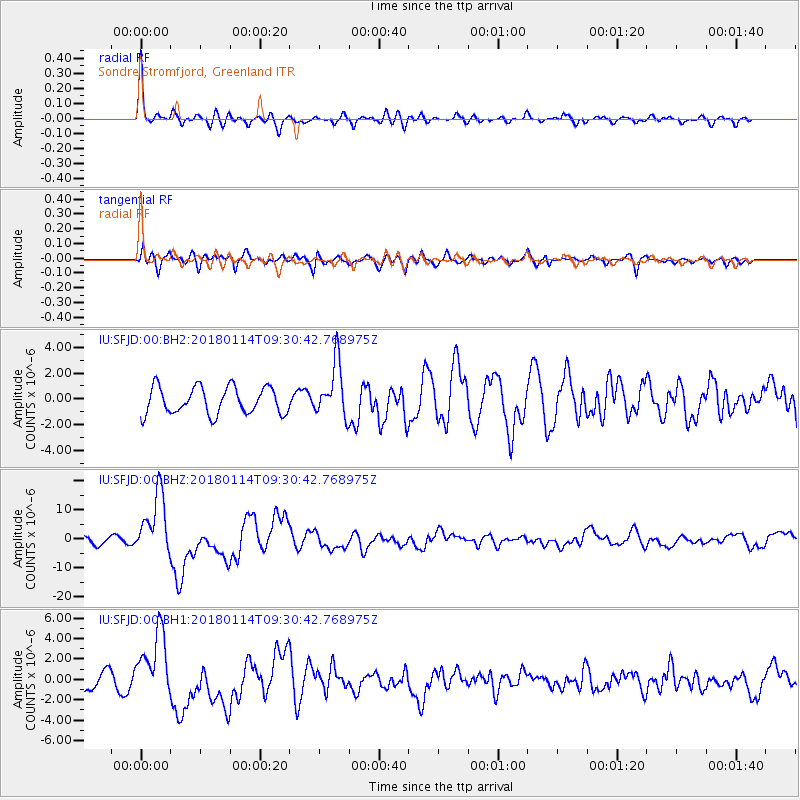
Signal To Noise
| Channel | StoN | STA | LTA |
| IU:SFJD:00:BHZ:20180114T09:30:42.768975Z | 7.7834997 | 1.0714316E-5 | 1.3765423E-6 |
| IU:SFJD:00:BH1:20180114T09:30:42.768975Z | 3.320613 | 3.2898895E-6 | 9.907477E-7 |
| IU:SFJD:00:BH2:20180114T09:30:42.768975Z | 2.0207713 | 2.1116778E-6 | 1.044986E-6 |
| Arrivals |
| Ps | 5.5 SECOND |
| PpPs | 22 SECOND |
| PsPs/PpSs | 27 SECOND |


