You are here: Home > Network List > IU - Global Seismograph Network (GSN - IRIS/USGS) Stations List
> Station TSUM Tsumeb, Namibia > Earthquake Result Viewer
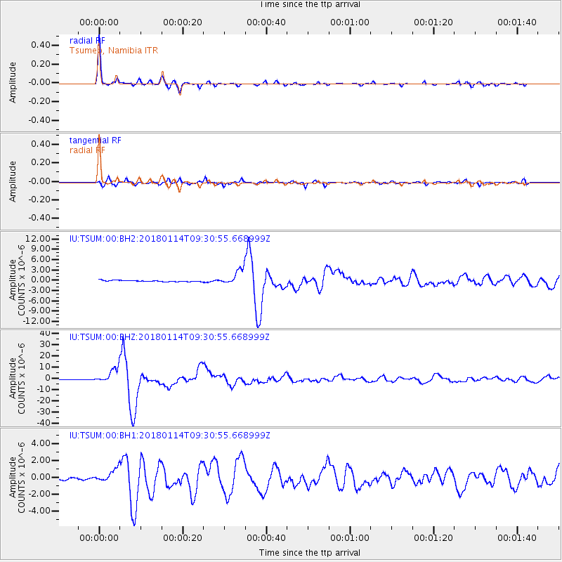
TSUM Tsumeb, Namibia - Earthquake Result Viewer

| Earthquake location: |
Near Coast Of Peru |
| Earthquake latitude/longitude: |
-15.8/-74.7 |
| Earthquake time(UTC): |
2018/01/14 (014) 09:18:45 GMT |
| Earthquake Depth: |
36 km |
| Earthquake Magnitude: |
7.1 mww |
| Earthquake Catalog/Contributor: |
NEIC PDE/us |
|
| Network: |
IU Global Seismograph Network (GSN - IRIS/USGS) |
| Station: |
TSUM Tsumeb, Namibia |
| Lat/Lon: |
19.20 S/17.58 E |
| Elevation: |
1260 m |
|
| Distance: |
87.1 deg |
| Az: |
109.001 deg |
| Baz: |
254.426 deg |
| Ray Param: |
0.043551054 |
| Estimated Moho Depth: |
36.25 km |
| Estimated Crust Vp/Vs: |
1.76 |
| Assumed Crust Vp: |
6.51 km/s |
| Estimated Crust Vs: |
3.694 km/s |
| Estimated Crust Poisson's Ratio: |
0.26 |
|
| Radial Match: |
98.3286 % |
| Radial Bump: |
256 |
| Transverse Match: |
91.98959 % |
| Transverse Bump: |
400 |
| SOD ConfigId: |
2537391 |
| Insert Time: |
2018-01-28 09:21:55.537 +0000 |
| GWidth: |
2.5 |
| Max Bumps: |
400 |
| Tol: |
0.001 |
|
Signal To Noise
| Channel | StoN | STA | LTA |
| IU:TSUM:00:BHZ:20180114T09:30:55.668999Z | 41.915024 | 6.647371E-6 | 1.585916E-7 |
| IU:TSUM:00:BH1:20180114T09:30:55.668999Z | 3.9569335 | 7.4994904E-7 | 1.8952784E-7 |
| IU:TSUM:00:BH2:20180114T09:30:55.668999Z | 13.32088 | 2.3138957E-6 | 1.7370444E-7 |
| Arrivals |
| Ps | 4.3 SECOND |
| PpPs | 15 SECOND |
| PsPs/PpSs | 19 SECOND |


