You are here: Home > Network List > IU - Global Seismograph Network (GSN - IRIS/USGS) Stations List
> Station XMAS Kiritimati Island, Republic of Kiribati > Earthquake Result Viewer
XMAS Kiritimati Island, Republic of Kiribati - Earthquake Result Viewer
| Earthquake location: |
Near Coast Of Peru |
| Earthquake latitude/longitude: |
-15.8/-74.7 |
| Earthquake time(UTC): |
2018/01/14 (014) 09:18:45 GMT |
| Earthquake Depth: |
36 km |
| Earthquake Magnitude: |
7.1 mww |
| Earthquake Catalog/Contributor: |
NEIC PDE/us |
|
| Network: |
IU Global Seismograph Network (GSN - IRIS/USGS) |
| Station: |
XMAS Kiritimati Island, Republic of Kiribati |
| Lat/Lon: |
2.04 N/157.45 W |
| Elevation: |
20 m |
|
| Distance: |
83.5 deg |
| Az: |
273.949 deg |
| Baz: |
106.028 deg |
| Ray Param: |
0.046070278 |
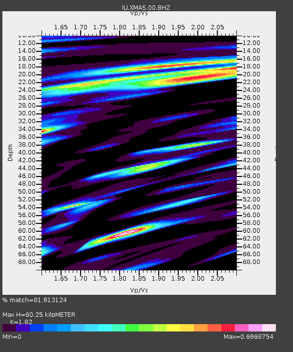
| Estimated Moho Depth: |
60.25 km |
| Estimated Crust Vp/Vs: |
1.82 |
| Assumed Crust Vp: |
4.802 km/s |
| Estimated Crust Vs: |
2.638 km/s |
| Estimated Crust Poisson's Ratio: |
0.28 |
|
| Radial Match: |
81.913124 % |
| Radial Bump: |
400 |
| Transverse Match: |
76.24742 % |
| Transverse Bump: |
400 |
| SOD ConfigId: |
2537391 |
| Insert Time: |
2018-01-28 09:21:58.416 +0000 |
| GWidth: |
2.5 |
| Max Bumps: |
400 |
| Tol: |
0.001 |
|

Signal To Noise
| Channel | StoN | STA | LTA |
| IU:XMAS:00:BHZ:20180114T09:30:38.143975Z | 3.5064096 | 4.9440114E-6 | 1.4099926E-6 |
| IU:XMAS:00:BH1:20180114T09:30:38.143975Z | 0.4876641 | 8.542977E-7 | 1.7518158E-6 |
| IU:XMAS:00:BH2:20180114T09:30:38.143975Z | 1.1926045 | 2.9467756E-6 | 2.470874E-6 |
| Arrivals |
| Ps | 10 SECOND |
| PpPs | 35 SECOND |
| PsPs/PpSs | 45 SECOND |


