You are here: Home > Network List > AV - Alaska Volcano Observatory Stations List
> Station GSIG Igitkin Island, Great Sitkin Volcano, Alaska > Earthquake Result Viewer
GSIG Igitkin Island, Great Sitkin Volcano, Alaska - Earthquake Result Viewer
| Earthquake location: |
California-Nevada Border Region |
| Earthquake latitude/longitude: |
38.5/-119.5 |
| Earthquake time(UTC): |
2021/07/08 (189) 22:49:48 GMT |
| Earthquake Depth: |
9.8 km |
| Earthquake Magnitude: |
5.9 mw |
| Earthquake Catalog/Contributor: |
NEIC PDE/nc |
|
| Network: |
AV Alaska Volcano Observatory |
| Station: |
GSIG Igitkin Island, Great Sitkin Volcano, Alaska |
| Lat/Lon: |
51.99 N/175.93 W |
| Elevation: |
407 m |
|
| Distance: |
40.9 deg |
| Az: |
308.118 deg |
| Baz: |
86.257 deg |
| Ray Param: |
0.07411708 |
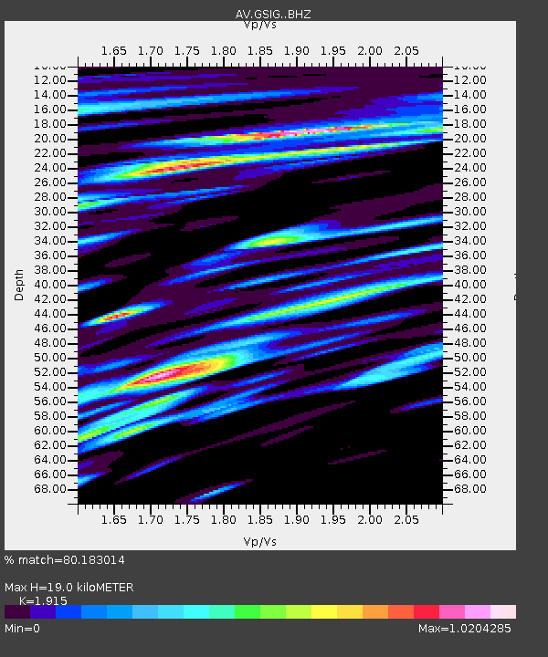
| Estimated Moho Depth: |
19.0 km |
| Estimated Crust Vp/Vs: |
1.91 |
| Assumed Crust Vp: |
3.943 km/s |
| Estimated Crust Vs: |
2.059 km/s |
| Estimated Crust Poisson's Ratio: |
0.31 |
|
| Radial Match: |
80.183014 % |
| Radial Bump: |
400 |
| Transverse Match: |
54.661026 % |
| Transverse Bump: |
400 |
| SOD ConfigId: |
25131211 |
| Insert Time: |
2021-07-22 22:51:53.171 +0000 |
| GWidth: |
2.5 |
| Max Bumps: |
400 |
| Tol: |
0.001 |
|

Signal To Noise
| Channel | StoN | STA | LTA |
| AV:GSIG: :BHZ:20210708T22:56:59.640007Z | 2.202355 | 2.6817756E-7 | 1.2176855E-7 |
| AV:GSIG: :BHN:20210708T22:56:59.640007Z | 1.1782578 | 2.8334046E-7 | 2.404741E-7 |
| AV:GSIG: :BHE:20210708T22:56:59.640007Z | 2.2877727 | 3.6992174E-7 | 1.6169516E-7 |
| Arrivals |
| Ps | 4.5 SECOND |
| PpPs | 14 SECOND |
| PsPs/PpSs | 18 SECOND |


