You are here: Home > Network List > IW - Intermountain West Stations List
> Station PHWY Pilot Hill, Wyoming, USA > Earthquake Result Viewer
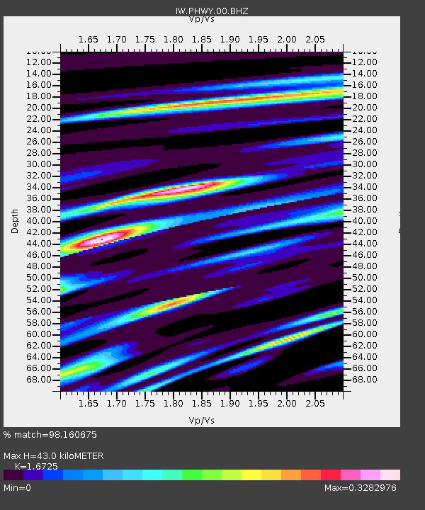
PHWY Pilot Hill, Wyoming, USA - Earthquake Result Viewer
| Earthquake location: |
Near Coast Of Peru |
| Earthquake latitude/longitude: |
-15.8/-74.7 |
| Earthquake time(UTC): |
2018/01/14 (014) 09:18:45 GMT |
| Earthquake Depth: |
36 km |
| Earthquake Magnitude: |
7.1 mww |
| Earthquake Catalog/Contributor: |
NEIC PDE/us |
|
| Network: |
IW Intermountain West |
| Station: |
PHWY Pilot Hill, Wyoming, USA |
| Lat/Lon: |
41.30 N/105.46 W |
| Elevation: |
2645 m |
|
| Distance: |
63.5 deg |
| Az: |
334.536 deg |
| Baz: |
146.672 deg |
| Ray Param: |
0.059466615 |
| Estimated Moho Depth: |
43.0 km |
| Estimated Crust Vp/Vs: |
1.67 |
| Assumed Crust Vp: |
6.306 km/s |
| Estimated Crust Vs: |
3.77 km/s |
| Estimated Crust Poisson's Ratio: |
0.22 |
|
| Radial Match: |
98.160675 % |
| Radial Bump: |
227 |
| Transverse Match: |
93.76874 % |
| Transverse Bump: |
400 |
| SOD ConfigId: |
2537391 |
| Insert Time: |
2018-01-28 09:22:05.732 +0000 |
| GWidth: |
2.5 |
| Max Bumps: |
400 |
| Tol: |
0.001 |
|

Signal To Noise
| Channel | StoN | STA | LTA |
| IW:PHWY:00:BHZ:20180114T09:28:40.885002Z | 36.50955 | 8.035566E-6 | 2.2009493E-7 |
| IW:PHWY:00:BH1:20180114T09:28:40.885002Z | 18.201023 | 2.3081693E-6 | 1.2681537E-7 |
| IW:PHWY:00:BH2:20180114T09:28:40.885002Z | 11.379666 | 2.005528E-6 | 1.7623786E-7 |
| Arrivals |
| Ps | 4.8 SECOND |
| PpPs | 17 SECOND |
| PsPs/PpSs | 22 SECOND |


