You are here: Home > Network List > HV - Hawaiian Volcano Observatory Network Stations List
> Station KKO Keanakakoi Crater > Earthquake Result Viewer
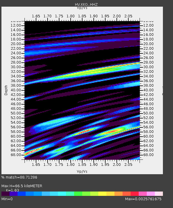
KKO Keanakakoi Crater - Earthquake Result Viewer
| Earthquake location: |
California-Nevada Border Region |
| Earthquake latitude/longitude: |
38.5/-119.5 |
| Earthquake time(UTC): |
2021/07/08 (189) 22:49:48 GMT |
| Earthquake Depth: |
9.8 km |
| Earthquake Magnitude: |
5.9 mw |
| Earthquake Catalog/Contributor: |
NEIC PDE/nc |
|
| Network: |
HV Hawaiian Volcano Observatory Network |
| Station: |
KKO Keanakakoi Crater |
| Lat/Lon: |
19.40 N/155.27 W |
| Elevation: |
1140 m |
|
| Distance: |
36.3 deg |
| Az: |
248.613 deg |
| Baz: |
50.693 deg |
| Ray Param: |
0.07676579 |
| Estimated Moho Depth: |
66.5 km |
| Estimated Crust Vp/Vs: |
1.63 |
| Assumed Crust Vp: |
5.195 km/s |
| Estimated Crust Vs: |
3.187 km/s |
| Estimated Crust Poisson's Ratio: |
0.20 |
|
| Radial Match: |
88.71286 % |
| Radial Bump: |
224 |
| Transverse Match: |
95.53002 % |
| Transverse Bump: |
130 |
| SOD ConfigId: |
25131211 |
| Insert Time: |
2021-07-22 22:55:27.735 +0000 |
| GWidth: |
2.5 |
| Max Bumps: |
400 |
| Tol: |
0.001 |
|

Signal To Noise
| Channel | StoN | STA | LTA |
| HV:KKO: :HHZ:20210708T22:56:21.25399Z | 4.0456123 | 9.3038625E-6 | 2.2997415E-6 |
| HV:KKO: :HHN:20210708T22:56:21.25399Z | 2.9757159 | 9.351568E-8 | 3.1426282E-8 |
| HV:KKO: :HHE:20210708T22:56:21.25399Z | 3.1350317 | 2.6193645E-8 | 8.355145E-9 |
| Arrivals |
| Ps | 8.5 SECOND |
| PpPs | 32 SECOND |
| PsPs/PpSs | 40 SECOND |


