You are here: Home > Network List > IW - Intermountain West Stations List
> Station SMCO Snowmass, Colorado, USA > Earthquake Result Viewer
SMCO Snowmass, Colorado, USA - Earthquake Result Viewer
| Earthquake location: |
Near Coast Of Peru |
| Earthquake latitude/longitude: |
-15.8/-74.7 |
| Earthquake time(UTC): |
2018/01/14 (014) 09:18:45 GMT |
| Earthquake Depth: |
36 km |
| Earthquake Magnitude: |
7.1 mww |
| Earthquake Catalog/Contributor: |
NEIC PDE/us |
|
| Network: |
IW Intermountain West |
| Station: |
SMCO Snowmass, Colorado, USA |
| Lat/Lon: |
39.18 N/106.97 W |
| Elevation: |
3435 m |
|
| Distance: |
62.4 deg |
| Az: |
332.116 deg |
| Baz: |
144.596 deg |
| Ray Param: |
0.06017607 |
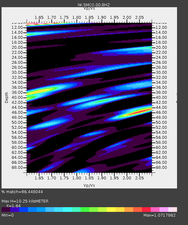
| Estimated Moho Depth: |
10.25 km |
| Estimated Crust Vp/Vs: |
1.64 |
| Assumed Crust Vp: |
6.306 km/s |
| Estimated Crust Vs: |
3.845 km/s |
| Estimated Crust Poisson's Ratio: |
0.20 |
|
| Radial Match: |
96.448044 % |
| Radial Bump: |
400 |
| Transverse Match: |
89.585724 % |
| Transverse Bump: |
400 |
| SOD ConfigId: |
2537391 |
| Insert Time: |
2018-01-28 09:22:11.439 +0000 |
| GWidth: |
2.5 |
| Max Bumps: |
400 |
| Tol: |
0.001 |
|

Signal To Noise
| Channel | StoN | STA | LTA |
| IW:SMCO:00:BHZ:20180114T09:28:33.600029Z | 22.325531 | 4.0530717E-6 | 1.8154425E-7 |
| IW:SMCO:00:BH1:20180114T09:28:33.600029Z | 4.914205 | 1.3050596E-6 | 2.6556881E-7 |
| IW:SMCO:00:BH2:20180114T09:28:33.600029Z | 4.7092376 | 1.1242206E-6 | 2.3872667E-7 |
| Arrivals |
| Ps | 1.1 SECOND |
| PpPs | 4.1 SECOND |
| PsPs/PpSs | 5.2 SECOND |


