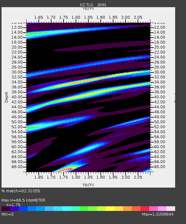
TLG Talgar, Kazakstan - Earthquake Result Viewer

Earthquake location: W. Caroline Islands, Micronesia
Earthquake latitude/longitude: 8.5/141.6
Earthquake time(UTC): 1996/07/04 (186) 15:50:38 GMT
Earthquake Depth: 33 km
Earthquake Magnitude: 5.1 MB, 5.4 MS, 6.0 UNKNOWN, 5.9 MW
Earthquake Catalog/Contributor: WHDF/NEIC
Network: KZ Kazakhstan Network
Station: TLG Talgar, Kazakstan
Lat/Lon: 43.23 N/77.22 E
Elevation: 1120 m
Distance: 65.6 deg
Az: 313.663 deg
Baz: 101.733 deg
Ray Param: 0.05811532
Estimated Moho Depth: 69.5 km
Estimated Crust Vp/Vs: 1.75
Assumed Crust Vp: 6.306 km/s
Estimated Crust Vs: 3.603 km/s
Estimated Crust Poisson's Ratio: 0.26
Radial Match: 82.31055 %
Radial Bump: 381
Transverse Match: 65.66727 %
Transverse Bump: 400
SOD ConfigId: 6273
Insert Time: 2010-03-09 10:02:01.523 +0000
GWidth: 2.5
Max Bumps: 400
Tol: 0.001

Signal To Noise

ChannelStoNSTALTA
KZ:TLG: :BHN:19960704T16:00:48.450Z1.87924953.8894635E-72.0696899E-7
KZ:TLG: :BHE:19960704T16:00:48.450Z3.8086311.4791532E-73.8836873E-8
KZ:TLG: :BHZ:19960704T16:00:48.450Z5.9758465.948735E-79.954632E-8
Arrivals
Ps8.6 SECOND
PpPs29 SECOND
PsPs/PpSs38 SECOND