You are here: Home > Network List > KZ - Kazakhstan Network Stations List
> Station TLG Talgar, Kazakstan > Earthquake Result Viewer
TLG Talgar, Kazakstan - Earthquake Result Viewer
| Earthquake location: |
Samar, Philippines |
| Earthquake latitude/longitude: |
11.8/125.5 |
| Earthquake time(UTC): |
1996/10/02 (276) 09:48:01 GMT |
| Earthquake Depth: |
33 km |
| Earthquake Magnitude: |
6.0 MB, 6.4 MS, 6.4 UNKNOWN, 6.3 MW |
| Earthquake Catalog/Contributor: |
WHDF/NEIC |
|
| Network: |
KZ Kazakhstan Network |
| Station: |
TLG Talgar, Kazakstan |
| Lat/Lon: |
43.23 N/77.22 E |
| Elevation: |
1120 m |
|
| Distance: |
52.1 deg |
| Az: |
316.258 deg |
| Baz: |
112.117 deg |
| Ray Param: |
0.066935346 |
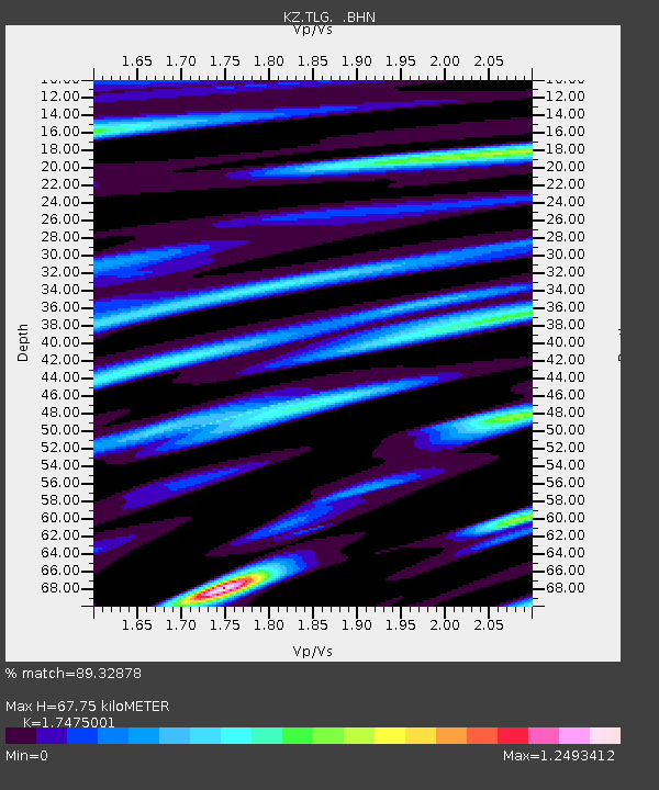
| Estimated Moho Depth: |
67.75 km |
| Estimated Crust Vp/Vs: |
1.75 |
| Assumed Crust Vp: |
6.306 km/s |
| Estimated Crust Vs: |
3.609 km/s |
| Estimated Crust Poisson's Ratio: |
0.26 |
|
| Radial Match: |
89.32878 % |
| Radial Bump: |
400 |
| Transverse Match: |
74.9425 % |
| Transverse Bump: |
400 |
| SOD ConfigId: |
6273 |
| Insert Time: |
2010-03-09 10:02:16.375 +0000 |
| GWidth: |
2.5 |
| Max Bumps: |
400 |
| Tol: |
0.001 |
|

Signal To Noise
| Channel | StoN | STA | LTA |
| KZ:TLG: :BHN:19961002T09:56:37.486023Z | 2.606769 | 4.059702E-7 | 1.5573693E-7 |
| KZ:TLG: :BHE:19961002T09:56:37.486023Z | 4.0613046 | 3.6700553E-7 | 9.036641E-8 |
| KZ:TLG: :BHZ:19961002T09:56:37.486023Z | 14.406089 | 1.5091255E-6 | 1.04756076E-7 |
| Arrivals |
| Ps | 8.5 SECOND |
| PpPs | 28 SECOND |
| PsPs/PpSs | 36 SECOND |


