You are here: Home > Network List > KZ - Kazakhstan Network Stations List
> Station TLG Talgar, Kazakstan > Earthquake Result Viewer
TLG Talgar, Kazakstan - Earthquake Result Viewer
| Earthquake location: |
Solomon Islands |
| Earthquake latitude/longitude: |
-7.1/155.6 |
| Earthquake time(UTC): |
1996/10/14 (288) 23:26:20 GMT |
| Earthquake Depth: |
24 km |
| Earthquake Magnitude: |
5.9 MB, 6.9 MS, 6.8 UNKNOWN, 6.3 ME |
| Earthquake Catalog/Contributor: |
WHDF/NEIC |
|
| Network: |
KZ Kazakhstan Network |
| Station: |
TLG Talgar, Kazakstan |
| Lat/Lon: |
43.23 N/77.22 E |
| Elevation: |
1120 m |
|
| Distance: |
86.4 deg |
| Az: |
314.177 deg |
| Baz: |
103.147 deg |
| Ray Param: |
0.044036575 |
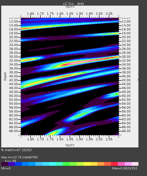
| Estimated Moho Depth: |
32.75 km |
| Estimated Crust Vp/Vs: |
1.89 |
| Assumed Crust Vp: |
6.306 km/s |
| Estimated Crust Vs: |
3.337 km/s |
| Estimated Crust Poisson's Ratio: |
0.31 |
|
| Radial Match: |
87.25253 % |
| Radial Bump: |
400 |
| Transverse Match: |
88.47863 % |
| Transverse Bump: |
400 |
| SOD ConfigId: |
6273 |
| Insert Time: |
2010-03-09 10:02:18.275 +0000 |
| GWidth: |
2.5 |
| Max Bumps: |
400 |
| Tol: |
0.001 |
|

Signal To Noise
| Channel | StoN | STA | LTA |
| KZ:TLG: :BHN:19961014T23:38:28.960022Z | 0.863189 | 8.981199E-8 | 1.0404673E-7 |
| KZ:TLG: :BHE:19961014T23:38:28.960022Z | 1.6549052 | 1.9752287E-7 | 1.19356E-7 |
| KZ:TLG: :BHZ:19961014T23:38:28.960022Z | 5.7708297 | 4.916637E-7 | 8.5198096E-8 |
| Arrivals |
| Ps | 4.7 SECOND |
| PpPs | 15 SECOND |
| PsPs/PpSs | 19 SECOND |


