You are here: Home > Network List > KZ - Kazakhstan Network Stations List
> Station TLG Talgar, Kazakstan > Earthquake Result Viewer
TLG Talgar, Kazakstan - Earthquake Result Viewer
| Earthquake location: |
Mid-Indian Ridge |
| Earthquake latitude/longitude: |
-11.4/66.2 |
| Earthquake time(UTC): |
1998/03/22 (081) 01:08:57 GMT |
| Earthquake Depth: |
10 km |
| Earthquake Magnitude: |
5.4 MB, 6.1 MS, 6.1 UNKNOWN, 6.1 MW |
| Earthquake Catalog/Contributor: |
WHDF/NEIC |
|
| Network: |
KZ Kazakhstan Network |
| Station: |
TLG Talgar, Kazakstan |
| Lat/Lon: |
43.23 N/77.22 E |
| Elevation: |
1120 m |
|
| Distance: |
55.3 deg |
| Az: |
9.746 deg |
| Baz: |
193.126 deg |
| Ray Param: |
0.06487311 |
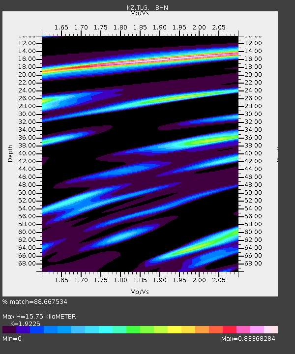
| Estimated Moho Depth: |
15.75 km |
| Estimated Crust Vp/Vs: |
1.92 |
| Assumed Crust Vp: |
6.306 km/s |
| Estimated Crust Vs: |
3.28 km/s |
| Estimated Crust Poisson's Ratio: |
0.31 |
|
| Radial Match: |
88.667534 % |
| Radial Bump: |
400 |
| Transverse Match: |
81.25182 % |
| Transverse Bump: |
400 |
| SOD ConfigId: |
6273 |
| Insert Time: |
2010-03-09 10:02:54.973 +0000 |
| GWidth: |
2.5 |
| Max Bumps: |
400 |
| Tol: |
0.001 |
|

Signal To Noise
| Channel | StoN | STA | LTA |
| KZ:TLG: :BHN:19980322T01:18:00.17301Z | 3.100293 | 8.706971E-8 | 2.8084349E-8 |
| KZ:TLG: :BHE:19980322T01:18:00.17301Z | 0.7642186 | 4.533313E-8 | 5.9319586E-8 |
| KZ:TLG: :BHZ:19980322T01:18:00.17301Z | 5.837175 | 2.5971647E-7 | 4.4493525E-8 |
| Arrivals |
| Ps | 2.4 SECOND |
| PpPs | 7.0 SECOND |
| PsPs/PpSs | 9.4 SECOND |


