You are here: Home > Network List > NM - Cooperative New Madrid Seismic Network Stations List
> Station GNAR Gosnell,AR > Earthquake Result Viewer
GNAR Gosnell,AR - Earthquake Result Viewer
| Earthquake location: |
Near Coast Of Peru |
| Earthquake latitude/longitude: |
-15.8/-74.7 |
| Earthquake time(UTC): |
2018/01/14 (014) 09:18:45 GMT |
| Earthquake Depth: |
36 km |
| Earthquake Magnitude: |
7.1 mww |
| Earthquake Catalog/Contributor: |
NEIC PDE/us |
|
| Network: |
NM Cooperative New Madrid Seismic Network |
| Station: |
GNAR Gosnell,AR |
| Lat/Lon: |
35.97 N/90.02 W |
| Elevation: |
71 m |
|
| Distance: |
53.5 deg |
| Az: |
344.572 deg |
| Baz: |
161.596 deg |
| Ray Param: |
0.06601768 |
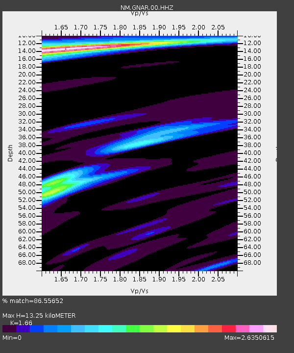
| Estimated Moho Depth: |
13.25 km |
| Estimated Crust Vp/Vs: |
1.66 |
| Assumed Crust Vp: |
6.273 km/s |
| Estimated Crust Vs: |
3.779 km/s |
| Estimated Crust Poisson's Ratio: |
0.22 |
|
| Radial Match: |
86.55652 % |
| Radial Bump: |
354 |
| Transverse Match: |
63.180275 % |
| Transverse Bump: |
400 |
| SOD ConfigId: |
2537391 |
| Insert Time: |
2018-01-28 09:22:51.760 +0000 |
| GWidth: |
2.5 |
| Max Bumps: |
400 |
| Tol: |
0.001 |
|

Signal To Noise
| Channel | StoN | STA | LTA |
| NM:GNAR:00:HHZ:20180114T09:27:30.919976Z | 31.692474 | 1.808198E-5 | 5.705449E-7 |
| NM:GNAR:00:HHN:20180114T09:27:30.919976Z | 6.278465 | 9.528112E-6 | 1.5175862E-6 |
| NM:GNAR:00:HHE:20180114T09:27:30.919976Z | 2.8395123 | 3.425683E-6 | 1.2064335E-6 |
| Arrivals |
| Ps | 1.5 SECOND |
| PpPs | 5.3 SECOND |
| PsPs/PpSs | 6.8 SECOND |


