You are here: Home > Network List > NM - Cooperative New Madrid Seismic Network Stations List
> Station HDAR2 I40 Weigh Station,West Memphis,AR > Earthquake Result Viewer
HDAR2 I40 Weigh Station,West Memphis,AR - Earthquake Result Viewer
| Earthquake location: |
Near Coast Of Peru |
| Earthquake latitude/longitude: |
-15.8/-74.7 |
| Earthquake time(UTC): |
2018/01/14 (014) 09:18:45 GMT |
| Earthquake Depth: |
36 km |
| Earthquake Magnitude: |
7.1 mww |
| Earthquake Catalog/Contributor: |
NEIC PDE/us |
|
| Network: |
NM Cooperative New Madrid Seismic Network |
| Station: |
HDAR2 I40 Weigh Station,West Memphis,AR |
| Lat/Lon: |
35.15 N/90.09 W |
| Elevation: |
100 m |
|
| Distance: |
52.7 deg |
| Az: |
344.18 deg |
| Baz: |
161.318 deg |
| Ray Param: |
0.06651894 |
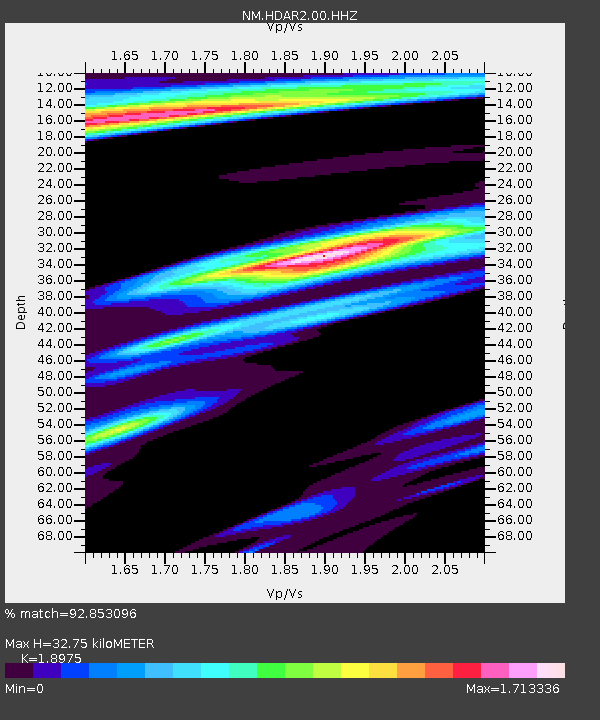
| Estimated Moho Depth: |
32.75 km |
| Estimated Crust Vp/Vs: |
1.90 |
| Assumed Crust Vp: |
6.273 km/s |
| Estimated Crust Vs: |
3.306 km/s |
| Estimated Crust Poisson's Ratio: |
0.31 |
|
| Radial Match: |
92.853096 % |
| Radial Bump: |
334 |
| Transverse Match: |
70.20042 % |
| Transverse Bump: |
400 |
| SOD ConfigId: |
2537391 |
| Insert Time: |
2018-01-28 09:22:55.708 +0000 |
| GWidth: |
2.5 |
| Max Bumps: |
400 |
| Tol: |
0.001 |
|
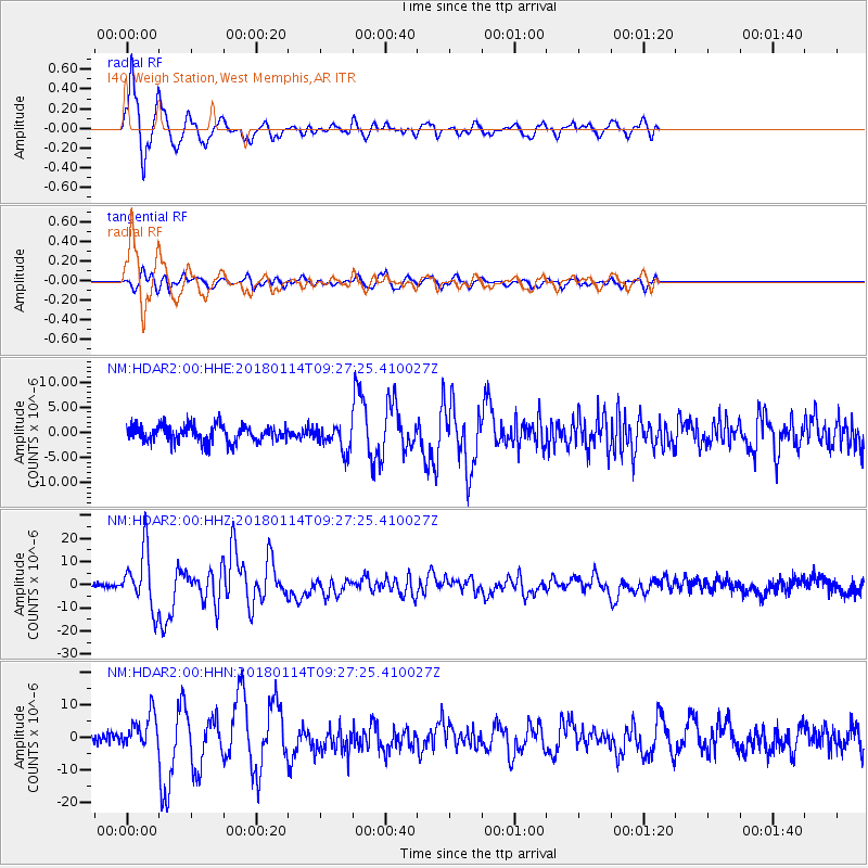
Signal To Noise
| Channel | StoN | STA | LTA |
| NM:HDAR2:00:HHZ:20180114T09:27:25.410027Z | 13.548449 | 1.2367359E-5 | 9.1282476E-7 |
| NM:HDAR2:00:HHN:20180114T09:27:25.410027Z | 3.3960674 | 5.3242784E-6 | 1.5677776E-6 |
| NM:HDAR2:00:HHE:20180114T09:27:25.410027Z | 1.5223236 | 2.5205177E-6 | 1.6557042E-6 |
| Arrivals |
| Ps | 4.9 SECOND |
| PpPs | 14 SECOND |
| PsPs/PpSs | 19 SECOND |


