You are here: Home > Network List > NM - Cooperative New Madrid Seismic Network Stations List
> Station LNXT Lenox,TN > Earthquake Result Viewer
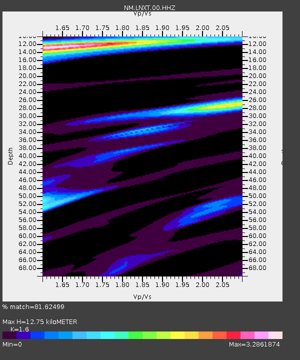
LNXT Lenox,TN - Earthquake Result Viewer
| Earthquake location: |
Near Coast Of Peru |
| Earthquake latitude/longitude: |
-15.8/-74.7 |
| Earthquake time(UTC): |
2018/01/14 (014) 09:18:45 GMT |
| Earthquake Depth: |
36 km |
| Earthquake Magnitude: |
7.1 mww |
| Earthquake Catalog/Contributor: |
NEIC PDE/us |
|
| Network: |
NM Cooperative New Madrid Seismic Network |
| Station: |
LNXT Lenox,TN |
| Lat/Lon: |
36.10 N/89.49 W |
| Elevation: |
144 m |
|
| Distance: |
53.4 deg |
| Az: |
345.13 deg |
| Baz: |
162.237 deg |
| Ray Param: |
0.06602008 |
| Estimated Moho Depth: |
12.75 km |
| Estimated Crust Vp/Vs: |
1.60 |
| Assumed Crust Vp: |
6.444 km/s |
| Estimated Crust Vs: |
4.027 km/s |
| Estimated Crust Poisson's Ratio: |
0.18 |
|
| Radial Match: |
81.62499 % |
| Radial Bump: |
400 |
| Transverse Match: |
41.527767 % |
| Transverse Bump: |
400 |
| SOD ConfigId: |
2537391 |
| Insert Time: |
2018-01-28 09:23:02.523 +0000 |
| GWidth: |
2.5 |
| Max Bumps: |
400 |
| Tol: |
0.001 |
|

Signal To Noise
| Channel | StoN | STA | LTA |
| NM:LNXT:00:HHZ:20180114T09:27:30.895012Z | 30.384712 | 1.6343949E-5 | 5.379004E-7 |
| NM:LNXT:00:HHN:20180114T09:27:30.895012Z | 8.413965 | 1.358898E-5 | 1.6150507E-6 |
| NM:LNXT:00:HHE:20180114T09:27:30.895012Z | 1.5976235 | 3.4080174E-6 | 2.1331794E-6 |
| Arrivals |
| Ps | 1.3 SECOND |
| PpPs | 4.8 SECOND |
| PsPs/PpSs | 6.1 SECOND |


