You are here: Home > Network List > US - United States National Seismic Network Stations List
> Station EGMT Eagleton, Montana, USA > Earthquake Result Viewer
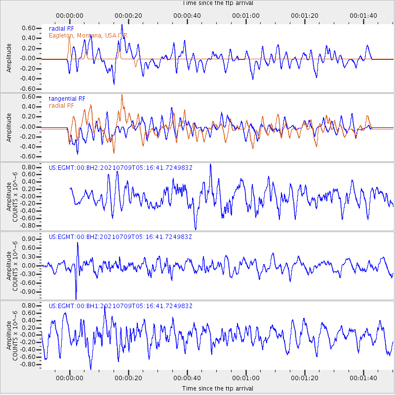
EGMT Eagleton, Montana, USA - Earthquake Result Viewer
*The percent match for this event was below the threshold and hence no stack was calculated.
| Earthquake location: |
Chile-Bolivia Border Region |
| Earthquake latitude/longitude: |
-20.3/-68.7 |
| Earthquake time(UTC): |
2021/07/09 (190) 05:05:30 GMT |
| Earthquake Depth: |
114 km |
| Earthquake Magnitude: |
5.2 Mww |
| Earthquake Catalog/Contributor: |
NEIC PDE/us |
|
| Network: |
US United States National Seismic Network |
| Station: |
EGMT Eagleton, Montana, USA |
| Lat/Lon: |
48.02 N/109.75 W |
| Elevation: |
1055 m |
|
| Distance: |
77.3 deg |
| Az: |
333.151 deg |
| Baz: |
140.843 deg |
| Ray Param: |
$rayparam |
*The percent match for this event was below the threshold and hence was not used in the summary stack. |
|
| Radial Match: |
38.6486 % |
| Radial Bump: |
400 |
| Transverse Match: |
46.33893 % |
| Transverse Bump: |
400 |
| SOD ConfigId: |
25131211 |
| Insert Time: |
2021-07-23 05:23:38.550 +0000 |
| GWidth: |
2.5 |
| Max Bumps: |
400 |
| Tol: |
0.001 |
|
Signal To Noise
| Channel | StoN | STA | LTA |
| US:EGMT:00:BHZ:20210709T05:16:41.724983Z | 3.2067528 | 3.354407E-7 | 1.0460448E-7 |
| US:EGMT:00:BH1:20210709T05:16:41.724983Z | 0.74134994 | 2.3303393E-7 | 3.1433729E-7 |
| US:EGMT:00:BH2:20210709T05:16:41.724983Z | 0.85531884 | 2.0439987E-7 | 2.3897505E-7 |
| Arrivals |
| Ps | |
| PpPs | |
| PsPs/PpSs | |


