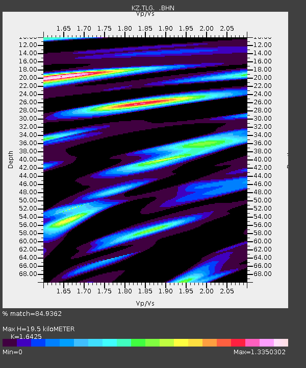
TLG Talgar, Kazakstan - Earthquake Result Viewer

Earthquake location: Southwest Of Sumatra, Indonesia
Earthquake latitude/longitude: -0.8/98.0
Earthquake time(UTC): 2000/05/08 (129) 12:29:59 GMT
Earthquake Depth: 33 km
Earthquake Magnitude: 5.6 MB, 5.3 MS, 5.9 MW, 5.6 MW
Earthquake Catalog/Contributor: WHDF/NEIC
Network: KZ Kazakhstan Network
Station: TLG Talgar, Kazakstan
Lat/Lon: 43.23 N/77.22 E
Elevation: 1120 m
Distance: 47.7 deg
Az: 339.479 deg
Baz: 151.342 deg
Ray Param: 0.069773376
Estimated Moho Depth: 19.5 km
Estimated Crust Vp/Vs: 1.64
Assumed Crust Vp: 6.306 km/s
Estimated Crust Vs: 3.839 km/s
Estimated Crust Poisson's Ratio: 0.21
Radial Match: 84.9362 %
Radial Bump: 400
Transverse Match: 85.32491 %
Transverse Bump: 400
SOD ConfigId: 3753
Insert Time: 2010-03-09 10:03:56.335 +0000
GWidth: 2.5
Max Bumps: 400
Tol: 0.001

Signal To Noise

ChannelStoNSTALTA
KZ:TLG: :BHN:20000508T12:38:02.549987Z2.71740461.551474E-75.7093967E-8
KZ:TLG: :BHE:20000508T12:38:02.549987Z1.84160598.695743E-84.721826E-8
KZ:TLG: :BHZ:20000508T12:38:02.549987Z4.4592033.729584E-78.3637914E-8
Arrivals
Ps2.1 SECOND
PpPs7.7 SECOND
PsPs/PpSs9.8 SECOND