You are here: Home > Network List > KZ - Kazakhstan Network Stations List
> Station TLG Talgar, Kazakstan > Earthquake Result Viewer
TLG Talgar, Kazakstan - Earthquake Result Viewer
| Earthquake location: |
New Britain Region, P.N.G. |
| Earthquake latitude/longitude: |
-4.5/150.0 |
| Earthquake time(UTC): |
2000/05/08 (129) 10:28:25 GMT |
| Earthquake Depth: |
502 km |
| Earthquake Magnitude: |
5.7 MB, 6.1 MW, 6.1 MW |
| Earthquake Catalog/Contributor: |
WHDF/NEIC |
|
| Network: |
KZ Kazakhstan Network |
| Station: |
TLG Talgar, Kazakstan |
| Lat/Lon: |
43.23 N/77.22 E |
| Elevation: |
1120 m |
|
| Distance: |
80.6 deg |
| Az: |
314.963 deg |
| Baz: |
105.152 deg |
| Ray Param: |
0.04668307 |
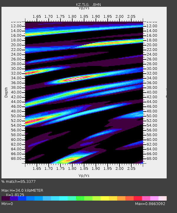
| Estimated Moho Depth: |
34.0 km |
| Estimated Crust Vp/Vs: |
1.81 |
| Assumed Crust Vp: |
6.306 km/s |
| Estimated Crust Vs: |
3.479 km/s |
| Estimated Crust Poisson's Ratio: |
0.28 |
|
| Radial Match: |
85.3377 % |
| Radial Bump: |
400 |
| Transverse Match: |
86.16576 % |
| Transverse Bump: |
400 |
| SOD ConfigId: |
3744 |
| Insert Time: |
2010-03-09 10:04:18.007 +0000 |
| GWidth: |
2.5 |
| Max Bumps: |
400 |
| Tol: |
0.001 |
|

Signal To Noise
| Channel | StoN | STA | LTA |
| KZ:TLG: :BHN:20000508T10:39:13.933013Z | 3.3805609 | 1.5965382E-7 | 4.722702E-8 |
| KZ:TLG: :BHE:20000508T10:39:13.933013Z | 6.614656 | 3.5947178E-7 | 5.4344742E-8 |
| KZ:TLG: :BHZ:20000508T10:39:13.933013Z | 15.833963 | 1.2125648E-6 | 7.6579994E-8 |
| Arrivals |
| Ps | 4.5 SECOND |
| PpPs | 15 SECOND |
| PsPs/PpSs | 19 SECOND |


