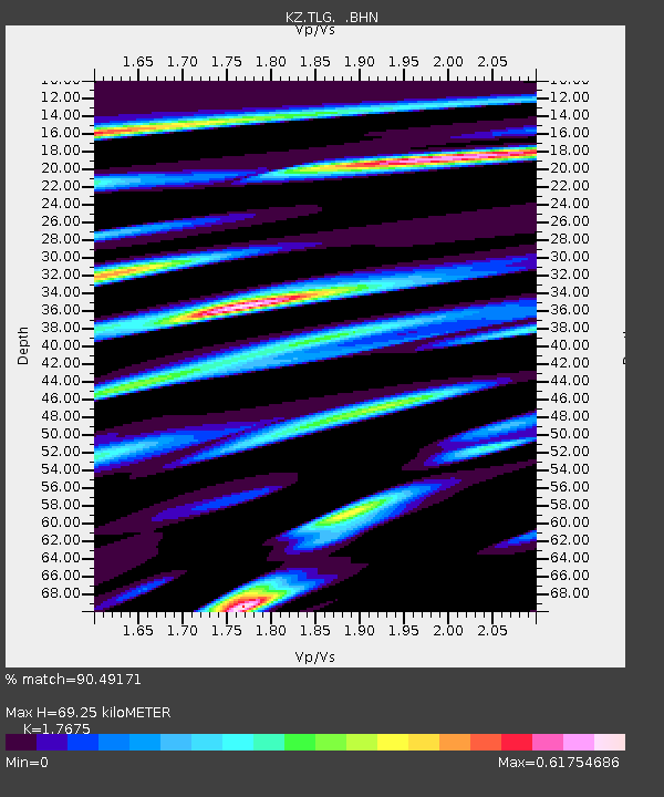
TLG Talgar, Kazakstan - Earthquake Result Viewer

Earthquake location: New Britain Region, P.N.G.
Earthquake latitude/longitude: -5.8/150.9
Earthquake time(UTC): 2000/02/06 (037) 11:33:52 GMT
Earthquake Depth: 33 km
Earthquake Magnitude: 6.6 MB, 6.8 MS, 6.6 MW, 6.3 ME
Earthquake Catalog/Contributor: WHDF/NEIC
Network: KZ Kazakhstan Network
Station: TLG Talgar, Kazakstan
Lat/Lon: 43.23 N/77.22 E
Elevation: 1120 m
Distance: 82.2 deg
Az: 314.939 deg
Baz: 105.517 deg
Ray Param: 0.047005232
Estimated Moho Depth: 69.25 km
Estimated Crust Vp/Vs: 1.77
Assumed Crust Vp: 6.306 km/s
Estimated Crust Vs: 3.568 km/s
Estimated Crust Poisson's Ratio: 0.26
Radial Match: 90.49171 %
Radial Bump: 400
Transverse Match: 86.08059 %
Transverse Bump: 400
SOD ConfigId: 3744
Insert Time: 2010-03-09 10:04:21.086 +0000
GWidth: 2.5
Max Bumps: 400
Tol: 0.001

Signal To Noise

ChannelStoNSTALTA
KZ:TLG: :BHN:20000206T11:45:38.894014Z20.841471.045999E-65.018835E-8
KZ:TLG: :BHE:20000206T11:45:38.894014Z15.9129321.945594E-61.2226496E-7
KZ:TLG: :BHZ:20000206T11:45:38.894014Z55.3618166.5067675E-61.17531684E-7
Arrivals
Ps8.6 SECOND
PpPs30 SECOND
PsPs/PpSs38 SECOND