You are here: Home > Network List > TX - Texas Seismological Network Stations List
> Station DRIO Del Rio > Earthquake Result Viewer
DRIO Del Rio - Earthquake Result Viewer
| Earthquake location: |
Near Coast Of Peru |
| Earthquake latitude/longitude: |
-15.8/-74.7 |
| Earthquake time(UTC): |
2018/01/14 (014) 09:18:45 GMT |
| Earthquake Depth: |
36 km |
| Earthquake Magnitude: |
7.1 mww |
| Earthquake Catalog/Contributor: |
NEIC PDE/us |
|
| Network: |
TX Texas Seismological Network |
| Station: |
DRIO Del Rio |
| Lat/Lon: |
29.42 N/100.62 W |
| Elevation: |
354 m |
|
| Distance: |
51.4 deg |
| Az: |
330.851 deg |
| Baz: |
147.483 deg |
| Ray Param: |
0.06735919 |
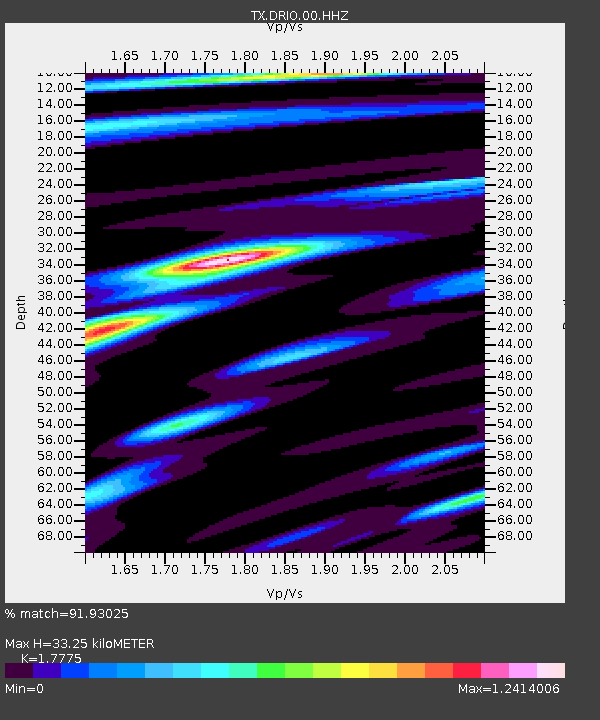
| Estimated Moho Depth: |
33.25 km |
| Estimated Crust Vp/Vs: |
1.78 |
| Assumed Crust Vp: |
6.12 km/s |
| Estimated Crust Vs: |
3.443 km/s |
| Estimated Crust Poisson's Ratio: |
0.27 |
|
| Radial Match: |
91.93025 % |
| Radial Bump: |
286 |
| Transverse Match: |
76.22522 % |
| Transverse Bump: |
400 |
| SOD ConfigId: |
2537391 |
| Insert Time: |
2018-01-28 09:23:34.617 +0000 |
| GWidth: |
2.5 |
| Max Bumps: |
400 |
| Tol: |
0.001 |
|

Signal To Noise
| Channel | StoN | STA | LTA |
| TX:DRIO:00:HHZ:20180114T09:27:15.835015Z | 53.4172 | 9.133493E-6 | 1.7098412E-7 |
| TX:DRIO:00:HH1:20180114T09:27:15.835015Z | 36.16566 | 4.391015E-6 | 1.2141393E-7 |
| TX:DRIO:00:HH2:20180114T09:27:15.835015Z | 21.359106 | 3.2372436E-6 | 1.5156269E-7 |
| Arrivals |
| Ps | 4.4 SECOND |
| PpPs | 14 SECOND |
| PsPs/PpSs | 19 SECOND |


