You are here: Home > Network List > AK - Alaska Regional Network Stations List
> Station N15K Kwethluk River, AK, USA > Earthquake Result Viewer
N15K Kwethluk River, AK, USA - Earthquake Result Viewer
| Earthquake location: |
Minahassa Peninsula, Sulawesi |
| Earthquake latitude/longitude: |
0.1/123.7 |
| Earthquake time(UTC): |
2021/07/09 (190) 13:31:09 GMT |
| Earthquake Depth: |
118 km |
| Earthquake Magnitude: |
5.6 mww |
| Earthquake Catalog/Contributor: |
NEIC PDE/us |
|
| Network: |
AK Alaska Regional Network |
| Station: |
N15K Kwethluk River, AK, USA |
| Lat/Lon: |
60.17 N/160.09 W |
| Elevation: |
449 m |
|
| Distance: |
83.1 deg |
| Az: |
29.281 deg |
| Baz: |
258.028 deg |
| Ray Param: |
0.046188526 |
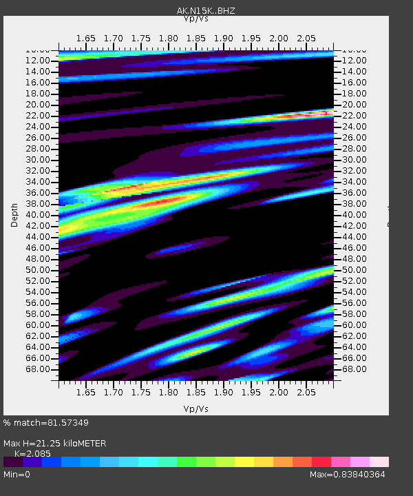
| Estimated Moho Depth: |
21.25 km |
| Estimated Crust Vp/Vs: |
2.09 |
| Assumed Crust Vp: |
6.182 km/s |
| Estimated Crust Vs: |
2.965 km/s |
| Estimated Crust Poisson's Ratio: |
0.35 |
|
| Radial Match: |
81.57349 % |
| Radial Bump: |
372 |
| Transverse Match: |
76.980156 % |
| Transverse Bump: |
400 |
| SOD ConfigId: |
25131211 |
| Insert Time: |
2021-07-23 13:34:14.901 +0000 |
| GWidth: |
2.5 |
| Max Bumps: |
400 |
| Tol: |
0.001 |
|

Signal To Noise
| Channel | StoN | STA | LTA |
| AK:N15K: :BHZ:20210709T13:42:50.579991Z | 22.017632 | 2.3700609E-6 | 1.07643764E-7 |
| AK:N15K: :BHN:20210709T13:42:50.579991Z | 5.220565 | 4.3898396E-7 | 8.4087446E-8 |
| AK:N15K: :BHE:20210709T13:42:50.579991Z | 4.1297097 | 5.0776737E-7 | 1.2295475E-7 |
| Arrivals |
| Ps | 3.8 SECOND |
| PpPs | 10 SECOND |
| PsPs/PpSs | 14 SECOND |


