You are here: Home > Network List > TX - Texas Seismological Network Stations List
> Station POST Post > Earthquake Result Viewer
POST Post - Earthquake Result Viewer
| Earthquake location: |
Near Coast Of Peru |
| Earthquake latitude/longitude: |
-15.8/-74.7 |
| Earthquake time(UTC): |
2018/01/14 (014) 09:18:45 GMT |
| Earthquake Depth: |
36 km |
| Earthquake Magnitude: |
7.1 mww |
| Earthquake Catalog/Contributor: |
NEIC PDE/us |
|
| Network: |
TX Texas Seismological Network |
| Station: |
POST Post |
| Lat/Lon: |
33.07 N/101.50 W |
| Elevation: |
795 m |
|
| Distance: |
54.9 deg |
| Az: |
332.474 deg |
| Baz: |
148.002 deg |
| Ray Param: |
0.065087736 |
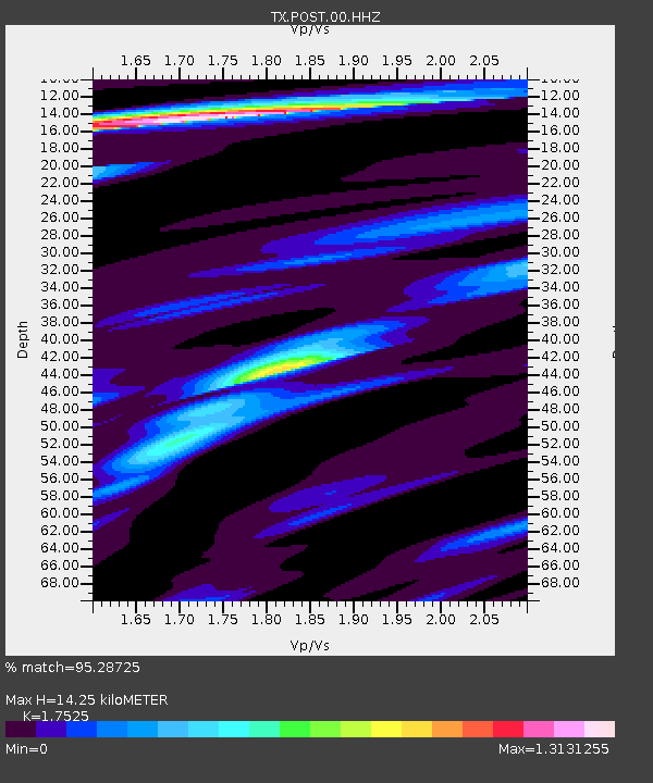
| Estimated Moho Depth: |
14.25 km |
| Estimated Crust Vp/Vs: |
1.75 |
| Assumed Crust Vp: |
6.426 km/s |
| Estimated Crust Vs: |
3.667 km/s |
| Estimated Crust Poisson's Ratio: |
0.26 |
|
| Radial Match: |
95.28725 % |
| Radial Bump: |
299 |
| Transverse Match: |
85.42672 % |
| Transverse Bump: |
400 |
| SOD ConfigId: |
2537391 |
| Insert Time: |
2018-01-28 09:23:49.801 +0000 |
| GWidth: |
2.5 |
| Max Bumps: |
400 |
| Tol: |
0.001 |
|

Signal To Noise
| Channel | StoN | STA | LTA |
| TX:POST:00:HHZ:20180114T09:27:41.34002Z | 87.31781 | 1.9601737E-5 | 2.2448728E-7 |
| TX:POST:00:HH1:20180114T09:27:41.34002Z | 38.00321 | 8.519563E-6 | 2.2418011E-7 |
| TX:POST:00:HH2:20180114T09:27:41.34002Z | 8.655384 | 1.9166696E-6 | 2.2144248E-7 |
| Arrivals |
| Ps | 1.8 SECOND |
| PpPs | 5.8 SECOND |
| PsPs/PpSs | 7.5 SECOND |


