You are here: Home > Network List > AV - Alaska Volcano Observatory Stations List
> Station KARR Katmai Rainbow River, Alaska > Earthquake Result Viewer
KARR Katmai Rainbow River, Alaska - Earthquake Result Viewer
| Earthquake location: |
Minahassa Peninsula, Sulawesi |
| Earthquake latitude/longitude: |
0.1/123.7 |
| Earthquake time(UTC): |
2021/07/09 (190) 13:31:09 GMT |
| Earthquake Depth: |
118 km |
| Earthquake Magnitude: |
5.6 mww |
| Earthquake Catalog/Contributor: |
NEIC PDE/us |
|
| Network: |
AV Alaska Volcano Observatory |
| Station: |
KARR Katmai Rainbow River, Alaska |
| Lat/Lon: |
58.50 N/154.71 W |
| Elevation: |
610 m |
|
| Distance: |
85.5 deg |
| Az: |
31.401 deg |
| Baz: |
262.866 deg |
| Ray Param: |
0.04445808 |
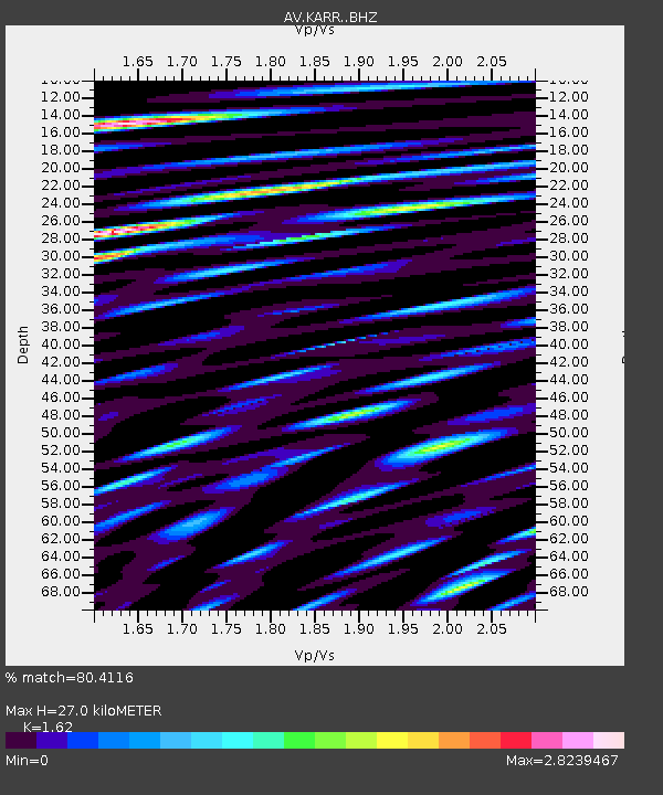
| Estimated Moho Depth: |
27.0 km |
| Estimated Crust Vp/Vs: |
1.62 |
| Assumed Crust Vp: |
6.438 km/s |
| Estimated Crust Vs: |
3.974 km/s |
| Estimated Crust Poisson's Ratio: |
0.19 |
|
| Radial Match: |
80.4116 % |
| Radial Bump: |
400 |
| Transverse Match: |
74.42681 % |
| Transverse Bump: |
400 |
| SOD ConfigId: |
25131211 |
| Insert Time: |
2021-07-23 13:36:56.706 +0000 |
| GWidth: |
2.5 |
| Max Bumps: |
400 |
| Tol: |
0.001 |
|
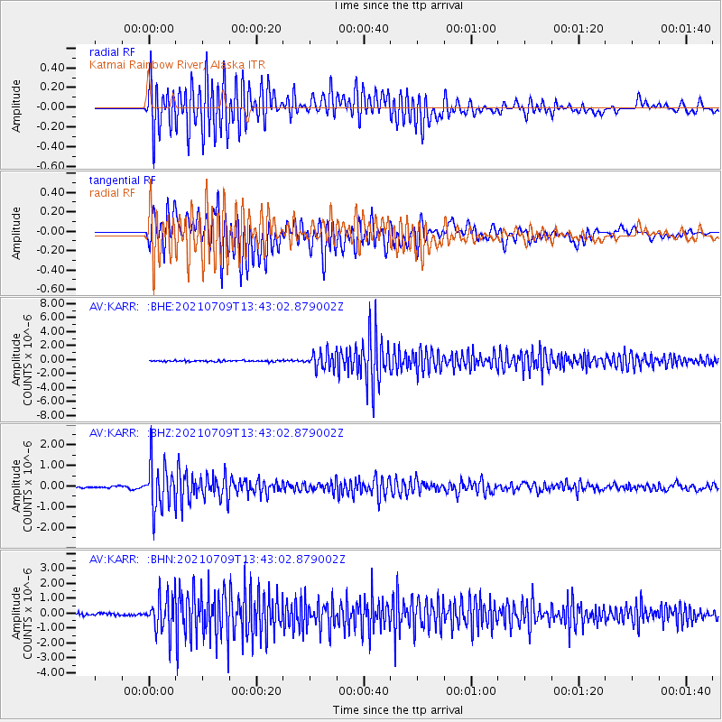
Signal To Noise
| Channel | StoN | STA | LTA |
| AV:KARR: :BHZ:20210709T13:43:02.879002Z | 24.303322 | 1.1239399E-6 | 4.624635E-8 |
| AV:KARR: :BHN:20210709T13:43:02.879002Z | 15.296754 | 1.2318695E-6 | 8.0531436E-8 |
| AV:KARR: :BHE:20210709T13:43:02.879002Z | 14.327539 | 1.1950951E-6 | 8.3412445E-8 |
| Arrivals |
| Ps | 2.7 SECOND |
| PpPs | 11 SECOND |
| PsPs/PpSs | 13 SECOND |


