You are here: Home > Network List > TX - Texas Seismological Network Stations List
> Station SN04 Snyder 4 > Earthquake Result Viewer
SN04 Snyder 4 - Earthquake Result Viewer
| Earthquake location: |
Near Coast Of Peru |
| Earthquake latitude/longitude: |
-15.8/-74.7 |
| Earthquake time(UTC): |
2018/01/14 (014) 09:18:45 GMT |
| Earthquake Depth: |
36 km |
| Earthquake Magnitude: |
7.1 mww |
| Earthquake Catalog/Contributor: |
NEIC PDE/us |
|
| Network: |
TX Texas Seismological Network |
| Station: |
SN04 Snyder 4 |
| Lat/Lon: |
32.90 N/100.87 W |
| Elevation: |
716 m |
|
| Distance: |
54.5 deg |
| Az: |
332.92 deg |
| Baz: |
148.602 deg |
| Ray Param: |
0.065363 |
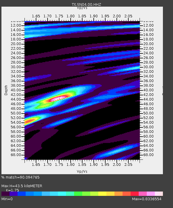
| Estimated Moho Depth: |
43.5 km |
| Estimated Crust Vp/Vs: |
1.75 |
| Assumed Crust Vp: |
6.426 km/s |
| Estimated Crust Vs: |
3.672 km/s |
| Estimated Crust Poisson's Ratio: |
0.26 |
|
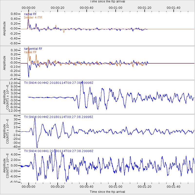
| Radial Match: |
90.094765 % |
| Radial Bump: |
251 |
| Transverse Match: |
88.92571 % |
| Transverse Bump: |
362 |
| SOD ConfigId: |
2537391 |
| Insert Time: |
2018-01-28 09:23:58.564 +0000 |
| GWidth: |
2.5 |
| Max Bumps: |
400 |
| Tol: |
0.001 |
|
Signal To Noise
| Channel | StoN | STA | LTA |
| TX:SN04:00:HHZ:20180114T09:27:38.29998Z | 39.295982 | 1.26054865E-5 | 3.2078307E-7 |
| TX:SN04:00:HH1:20180114T09:27:38.29998Z | 7.1792717 | 1.692524E-6 | 2.357515E-7 |
| TX:SN04:00:HH2:20180114T09:27:38.29998Z | 18.197332 | 3.4298296E-6 | 1.884798E-7 |
| Arrivals |
| Ps | 5.4 SECOND |
| PpPs | 18 SECOND |
| PsPs/PpSs | 23 SECOND |


