You are here: Home > Network List > CN - Canadian National Seismograph Network Stations List
> Station INK INUVIK, NT > Earthquake Result Viewer
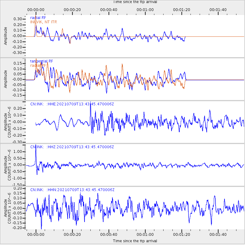
INK INUVIK, NT - Earthquake Result Viewer
*The percent match for this event was below the threshold and hence no stack was calculated.
| Earthquake location: |
Minahassa Peninsula, Sulawesi |
| Earthquake latitude/longitude: |
0.1/123.7 |
| Earthquake time(UTC): |
2021/07/09 (190) 13:31:09 GMT |
| Earthquake Depth: |
118 km |
| Earthquake Magnitude: |
5.6 mww |
| Earthquake Catalog/Contributor: |
NEIC PDE/us |
|
| Network: |
CN Canadian National Seismograph Network |
| Station: |
INK INUVIK, NT |
| Lat/Lon: |
68.31 N/133.53 W |
| Elevation: |
44 m |
|
| Distance: |
94.6 deg |
| Az: |
21.333 deg |
| Baz: |
281.903 deg |
| Ray Param: |
$rayparam |
*The percent match for this event was below the threshold and hence was not used in the summary stack. |
|
| Radial Match: |
68.71699 % |
| Radial Bump: |
400 |
| Transverse Match: |
51.943855 % |
| Transverse Bump: |
400 |
| SOD ConfigId: |
25131211 |
| Insert Time: |
2021-07-23 13:38:29.729 +0000 |
| GWidth: |
2.5 |
| Max Bumps: |
400 |
| Tol: |
0.001 |
|
Signal To Noise
| Channel | StoN | STA | LTA |
| CN:INK: :HHZ:20210709T13:43:45.470006Z | 5.1565285 | 4.0215807E-7 | 7.799008E-8 |
| CN:INK: :HHN:20210709T13:43:45.470006Z | 0.984942 | 6.14923E-8 | 6.2432406E-8 |
| CN:INK: :HHE:20210709T13:43:45.470006Z | 2.249056 | 9.890939E-8 | 4.397818E-8 |
| Arrivals |
| Ps | |
| PpPs | |
| PsPs/PpSs | |


