You are here: Home > Network List > CN - Canadian National Seismograph Network Stations List
> Station YUK7 Dusty Glacier, YT, CA > Earthquake Result Viewer
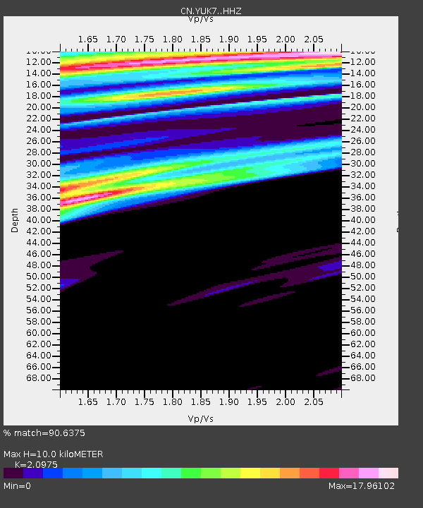
YUK7 Dusty Glacier, YT, CA - Earthquake Result Viewer
| Earthquake location: |
Minahassa Peninsula, Sulawesi |
| Earthquake latitude/longitude: |
0.1/123.7 |
| Earthquake time(UTC): |
2021/07/09 (190) 13:31:09 GMT |
| Earthquake Depth: |
118 km |
| Earthquake Magnitude: |
5.6 mww |
| Earthquake Catalog/Contributor: |
NEIC PDE/us |
|
| Network: |
CN Canadian National Seismograph Network |
| Station: |
YUK7 Dusty Glacier, YT, CA |
| Lat/Lon: |
60.53 N/138.14 W |
| Elevation: |
1992 m |
|
| Distance: |
93.9 deg |
| Az: |
29.382 deg |
| Baz: |
277.135 deg |
| Ray Param: |
0.041084725 |
| Estimated Moho Depth: |
10.0 km |
| Estimated Crust Vp/Vs: |
2.10 |
| Assumed Crust Vp: |
6.566 km/s |
| Estimated Crust Vs: |
3.13 km/s |
| Estimated Crust Poisson's Ratio: |
0.35 |
|
| Radial Match: |
90.6375 % |
| Radial Bump: |
356 |
| Transverse Match: |
74.91545 % |
| Transverse Bump: |
290 |
| SOD ConfigId: |
25131211 |
| Insert Time: |
2021-07-23 13:38:39.452 +0000 |
| GWidth: |
2.5 |
| Max Bumps: |
400 |
| Tol: |
0.001 |
|

Signal To Noise
| Channel | StoN | STA | LTA |
| CN:YUK7: :HHZ:20210709T13:43:42.340001Z | 3.0201886 | 5.7138305E-7 | 1.8918787E-7 |
| CN:YUK7: :HHN:20210709T13:43:42.340001Z | 0.9252846 | 8.694182E-6 | 9.3962235E-6 |
| CN:YUK7: :HHE:20210709T13:43:42.340001Z | 1.5805027 | 8.519701E-6 | 5.3905005E-6 |
| Arrivals |
| Ps | 1.7 SECOND |
| PpPs | 4.6 SECOND |
| PsPs/PpSs | 6.3 SECOND |


