You are here: Home > Network List > TX - Texas Seismological Network Stations List
> Station CRHG Carthage > Earthquake Result Viewer
CRHG Carthage - Earthquake Result Viewer
| Earthquake location: |
Near Coast Of Peru |
| Earthquake latitude/longitude: |
-15.8/-74.7 |
| Earthquake time(UTC): |
2018/01/14 (014) 09:18:45 GMT |
| Earthquake Depth: |
36 km |
| Earthquake Magnitude: |
7.1 mww |
| Earthquake Catalog/Contributor: |
NEIC PDE/us |
|
| Network: |
TX Texas Seismological Network |
| Station: |
CRHG Carthage |
| Lat/Lon: |
32.29 N/94.23 W |
| Elevation: |
95 m |
|
| Distance: |
51.3 deg |
| Az: |
338.783 deg |
| Baz: |
155.708 deg |
| Ray Param: |
0.06742681 |
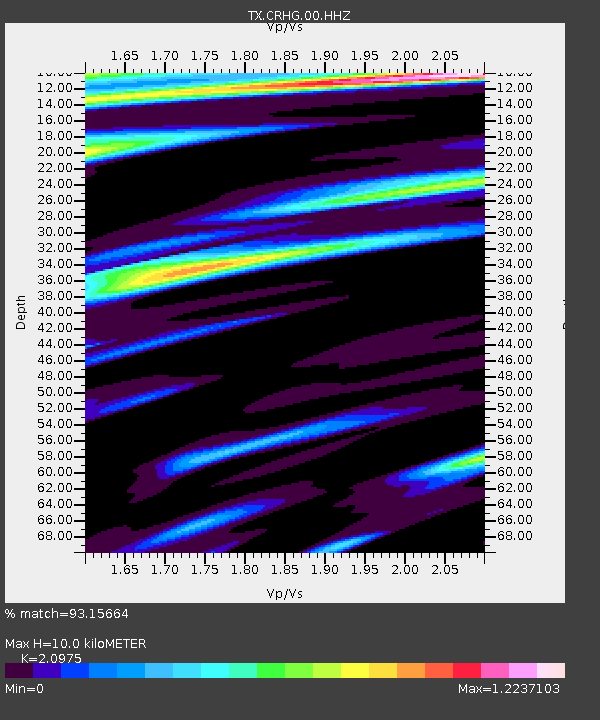
| Estimated Moho Depth: |
10.0 km |
| Estimated Crust Vp/Vs: |
2.10 |
| Assumed Crust Vp: |
6.245 km/s |
| Estimated Crust Vs: |
2.977 km/s |
| Estimated Crust Poisson's Ratio: |
0.35 |
|
| Radial Match: |
93.15664 % |
| Radial Bump: |
400 |
| Transverse Match: |
87.796906 % |
| Transverse Bump: |
400 |
| SOD ConfigId: |
2537391 |
| Insert Time: |
2018-01-28 09:24:05.400 +0000 |
| GWidth: |
2.5 |
| Max Bumps: |
400 |
| Tol: |
0.001 |
|

Signal To Noise
| Channel | StoN | STA | LTA |
| TX:CRHG:00:HHZ:20180114T09:27:15.040001Z | 21.7636 | 8.899846E-6 | 4.089326E-7 |
| TX:CRHG:00:HH1:20180114T09:27:15.040001Z | 3.428772 | 2.159909E-6 | 6.2993655E-7 |
| TX:CRHG:00:HH2:20180114T09:27:15.040001Z | 1.9771477 | 1.1663137E-6 | 5.898971E-7 |
| Arrivals |
| Ps | 1.8 SECOND |
| PpPs | 4.7 SECOND |
| PsPs/PpSs | 6.6 SECOND |


