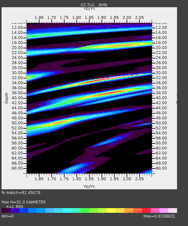
TLG Talgar, Kazakstan - Earthquake Result Viewer

Earthquake location: New Britain Region, P.N.G.
Earthquake latitude/longitude: -5.9/150.2
Earthquake time(UTC): 2001/10/31 (304) 09:10:20 GMT
Earthquake Depth: 33 km
Earthquake Magnitude: 5.9 MB, 6.9 MS, 6.9 MW, 6.9 MW
Earthquake Catalog/Contributor: WHDF/NEIC
Network: KZ Kazakhstan Network
Station: TLG Talgar, Kazakstan
Lat/Lon: 43.23 N/77.22 E
Elevation: 1120 m
Distance: 81.8 deg
Az: 315.083 deg
Baz: 106.049 deg
Ray Param: 0.047305685
Estimated Moho Depth: 31.0 km
Estimated Crust Vp/Vs: 1.99
Assumed Crust Vp: 6.306 km/s
Estimated Crust Vs: 3.177 km/s
Estimated Crust Poisson's Ratio: 0.33
Radial Match: 92.45078 %
Radial Bump: 400
Transverse Match: 88.81878 %
Transverse Bump: 400
SOD ConfigId: 20082
Insert Time: 2010-03-09 10:05:37.900 +0000
GWidth: 2.5
Max Bumps: 400
Tol: 0.001

Signal To Noise

ChannelStoNSTALTA
KZ:TLG: :BHN:20011031T09:22:04.356018Z1.28325391.1345361E-78.841088E-8
KZ:TLG: :BHE:20011031T09:22:04.356018Z1.63812982.5900653E-71.581111E-7
KZ:TLG: :BHZ:20011031T09:22:04.356018Z7.197877.798879E-71.0834982E-7
Arrivals
Ps5.0 SECOND
PpPs14 SECOND
PsPs/PpSs19 SECOND