You are here: Home > Network List > TA - USArray Transportable Network (new EarthScope stations) Stations List
> Station A36M Sachs Harbour, NT, CAN > Earthquake Result Viewer
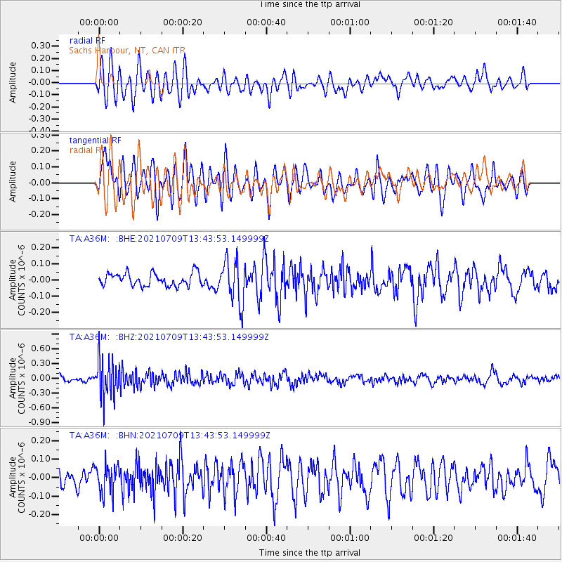
A36M Sachs Harbour, NT, CAN - Earthquake Result Viewer
*The percent match for this event was below the threshold and hence no stack was calculated.
| Earthquake location: |
Minahassa Peninsula, Sulawesi |
| Earthquake latitude/longitude: |
0.1/123.7 |
| Earthquake time(UTC): |
2021/07/09 (190) 13:31:09 GMT |
| Earthquake Depth: |
118 km |
| Earthquake Magnitude: |
5.6 mww |
| Earthquake Catalog/Contributor: |
NEIC PDE/us |
|
| Network: |
TA USArray Transportable Network (new EarthScope stations) |
| Station: |
A36M Sachs Harbour, NT, CAN |
| Lat/Lon: |
71.99 N/125.25 W |
| Elevation: |
32 m |
|
| Distance: |
96.3 deg |
| Az: |
16.987 deg |
| Baz: |
290.104 deg |
| Ray Param: |
$rayparam |
*The percent match for this event was below the threshold and hence was not used in the summary stack. |
|
| Radial Match: |
63.38881 % |
| Radial Bump: |
400 |
| Transverse Match: |
56.69585 % |
| Transverse Bump: |
400 |
| SOD ConfigId: |
25131211 |
| Insert Time: |
2021-07-23 13:41:49.017 +0000 |
| GWidth: |
2.5 |
| Max Bumps: |
400 |
| Tol: |
0.001 |
|
Signal To Noise
| Channel | StoN | STA | LTA |
| TA:A36M: :BHZ:20210709T13:43:53.149999Z | 5.469602 | 3.8853028E-7 | 7.103447E-8 |
| TA:A36M: :BHN:20210709T13:43:53.149999Z | 1.3153563 | 7.8046895E-8 | 5.9335175E-8 |
| TA:A36M: :BHE:20210709T13:43:53.149999Z | 3.566406 | 1.3907734E-7 | 3.8996497E-8 |
| Arrivals |
| Ps | |
| PpPs | |
| PsPs/PpSs | |


