You are here: Home > Network List > TA - USArray Transportable Network (new EarthScope stations) Stations List
> Station P32M Atlin, BC, CAN > Earthquake Result Viewer
P32M Atlin, BC, CAN - Earthquake Result Viewer
*The percent match for this event was below the threshold and hence no stack was calculated.
| Earthquake location: |
Minahassa Peninsula, Sulawesi |
| Earthquake latitude/longitude: |
0.1/123.7 |
| Earthquake time(UTC): |
2021/07/09 (190) 13:31:09 GMT |
| Earthquake Depth: |
118 km |
| Earthquake Magnitude: |
5.6 mww |
| Earthquake Catalog/Contributor: |
NEIC PDE/us |
|
| Network: |
TA USArray Transportable Network (new EarthScope stations) |
| Station: |
P32M Atlin, BC, CAN |
| Lat/Lon: |
59.59 N/133.71 W |
| Elevation: |
793 m |
|
| Distance: |
96.3 deg |
| Az: |
29.968 deg |
| Baz: |
280.911 deg |
| Ray Param: |
$rayparam |
*The percent match for this event was below the threshold and hence was not used in the summary stack. |
|
| Radial Match: |
57.938995 % |
| Radial Bump: |
400 |
| Transverse Match: |
69.17033 % |
| Transverse Bump: |
400 |
| SOD ConfigId: |
25131211 |
| Insert Time: |
2021-07-23 13:42:08.917 +0000 |
| GWidth: |
2.5 |
| Max Bumps: |
400 |
| Tol: |
0.001 |
|
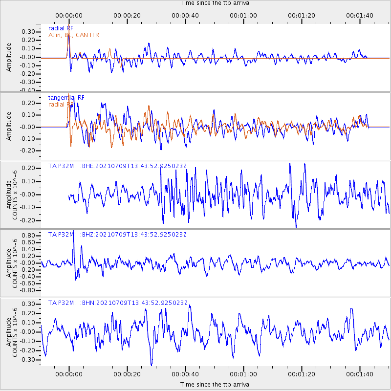
Signal To Noise
| Channel | StoN | STA | LTA |
| TA:P32M: :BHZ:20210709T13:43:52.925023Z | 5.0256815 | 3.103884E-7 | 6.176046E-8 |
| TA:P32M: :BHN:20210709T13:43:52.925023Z | 0.8862323 | 6.731524E-8 | 7.595665E-8 |
| TA:P32M: :BHE:20210709T13:43:52.925023Z | 1.9234658 | 8.966269E-8 | 4.661517E-8 |
| Arrivals |
| Ps | |
| PpPs | |
| PsPs/PpSs | |


