You are here: Home > Network List > TX - Texas Seismological Network Stations List
> Station SNAG San Augustine > Earthquake Result Viewer
SNAG San Augustine - Earthquake Result Viewer
| Earthquake location: |
Near Coast Of Peru |
| Earthquake latitude/longitude: |
-15.8/-74.7 |
| Earthquake time(UTC): |
2018/01/14 (014) 09:18:45 GMT |
| Earthquake Depth: |
36 km |
| Earthquake Magnitude: |
7.1 mww |
| Earthquake Catalog/Contributor: |
NEIC PDE/us |
|
| Network: |
TX Texas Seismological Network |
| Station: |
SNAG San Augustine |
| Lat/Lon: |
31.52 N/94.18 W |
| Elevation: |
84 m |
|
| Distance: |
50.6 deg |
| Az: |
338.421 deg |
| Baz: |
155.504 deg |
| Ray Param: |
0.06787787 |
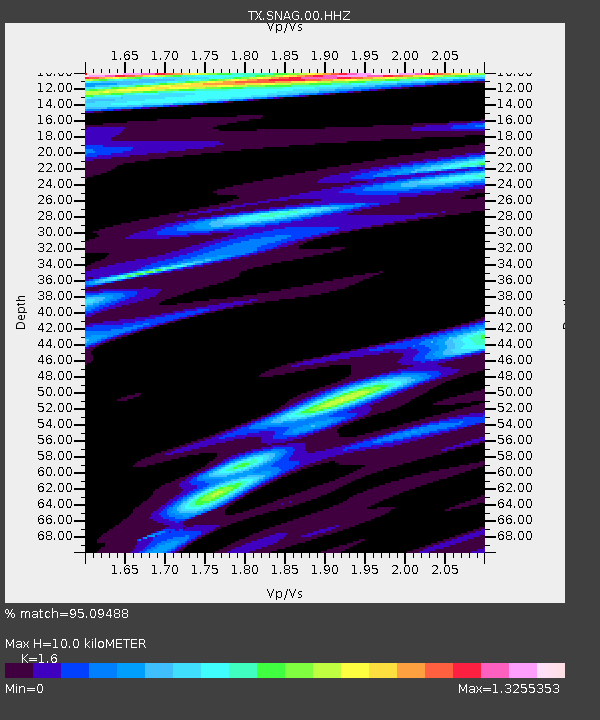
| Estimated Moho Depth: |
10.0 km |
| Estimated Crust Vp/Vs: |
1.60 |
| Assumed Crust Vp: |
5.738 km/s |
| Estimated Crust Vs: |
3.587 km/s |
| Estimated Crust Poisson's Ratio: |
0.18 |
|
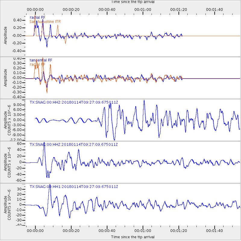
| Radial Match: |
95.09488 % |
| Radial Bump: |
261 |
| Transverse Match: |
88.77323 % |
| Transverse Bump: |
322 |
| SOD ConfigId: |
2537391 |
| Insert Time: |
2018-01-28 09:24:22.798 +0000 |
| GWidth: |
2.5 |
| Max Bumps: |
400 |
| Tol: |
0.001 |
|
Signal To Noise
| Channel | StoN | STA | LTA |
| TX:SNAG:00:HHZ:20180114T09:27:09.675011Z | 89.934105 | 1.5729238E-5 | 1.7489737E-7 |
| TX:SNAG:00:HH1:20180114T09:27:09.675011Z | 11.097296 | 3.7547175E-6 | 3.3834527E-7 |
| TX:SNAG:00:HH2:20180114T09:27:09.675011Z | 0.67149824 | 5.4666435E-7 | 8.140965E-7 |
| Arrivals |
| Ps | 1.1 SECOND |
| PpPs | 4.3 SECOND |
| PsPs/PpSs | 5.4 SECOND |


