You are here: Home > Network List > AK - Alaska Regional Network Stations List
> Station H23K Yukon River, AK, USA > Earthquake Result Viewer
H23K Yukon River, AK, USA - Earthquake Result Viewer
| Earthquake location: |
Northern Molucca Sea |
| Earthquake latitude/longitude: |
2.9/126.5 |
| Earthquake time(UTC): |
2021/07/10 (191) 00:43:56 GMT |
| Earthquake Depth: |
45 km |
| Earthquake Magnitude: |
6.1 Mww |
| Earthquake Catalog/Contributor: |
NEIC PDE/us |
|
| Network: |
AK Alaska Regional Network |
| Station: |
H23K Yukon River, AK, USA |
| Lat/Lon: |
65.83 N/149.54 W |
| Elevation: |
617 m |
|
| Distance: |
84.9 deg |
| Az: |
24.28 deg |
| Baz: |
265.695 deg |
| Ray Param: |
0.04511595 |
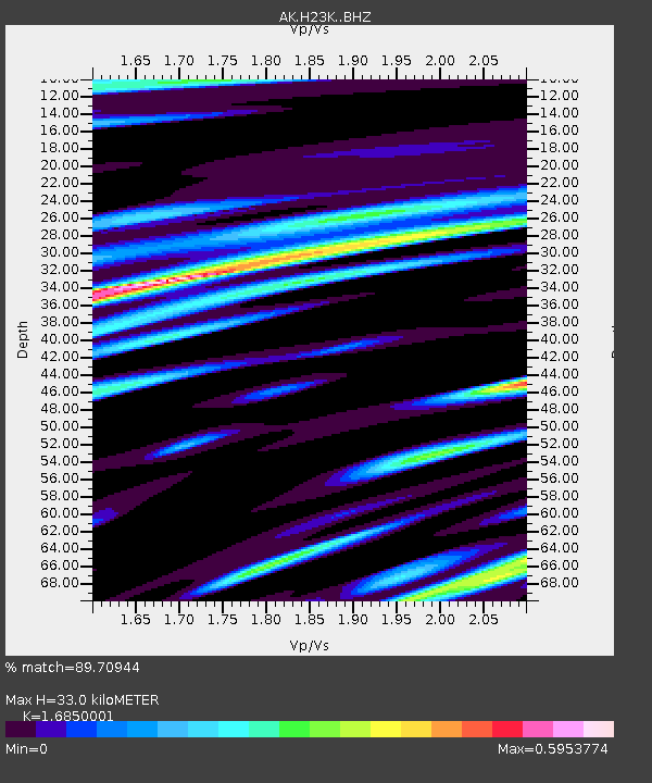
| Estimated Moho Depth: |
33.0 km |
| Estimated Crust Vp/Vs: |
1.69 |
| Assumed Crust Vp: |
6.566 km/s |
| Estimated Crust Vs: |
3.897 km/s |
| Estimated Crust Poisson's Ratio: |
0.23 |
|
| Radial Match: |
89.70944 % |
| Radial Bump: |
400 |
| Transverse Match: |
80.388084 % |
| Transverse Bump: |
400 |
| SOD ConfigId: |
25131211 |
| Insert Time: |
2021-07-24 00:45:42.523 +0000 |
| GWidth: |
2.5 |
| Max Bumps: |
400 |
| Tol: |
0.001 |
|

Signal To Noise
| Channel | StoN | STA | LTA |
| AK:H23K: :BHZ:20210710T00:55:54.800009Z | 10.639074 | 8.15147E-7 | 7.661822E-8 |
| AK:H23K: :BHN:20210710T00:55:54.800009Z | 2.8005178 | 1.6962264E-7 | 6.056832E-8 |
| AK:H23K: :BHE:20210710T00:55:54.800009Z | 5.3555627 | 2.7943884E-7 | 5.2177306E-8 |
| Arrivals |
| Ps | 3.5 SECOND |
| PpPs | 13 SECOND |
| PsPs/PpSs | 17 SECOND |


