You are here: Home > Network List > TX - Texas Seismological Network Stations List
> Station PB06 Permian Basin 6 > Earthquake Result Viewer
PB06 Permian Basin 6 - Earthquake Result Viewer
| Earthquake location: |
Near Coast Of Peru |
| Earthquake latitude/longitude: |
-15.8/-74.7 |
| Earthquake time(UTC): |
2018/01/14 (014) 09:18:45 GMT |
| Earthquake Depth: |
36 km |
| Earthquake Magnitude: |
7.1 mww |
| Earthquake Catalog/Contributor: |
NEIC PDE/us |
|
| Network: |
TX Texas Seismological Network |
| Station: |
PB06 Permian Basin 6 |
| Lat/Lon: |
31.65 N/103.22 W |
| Elevation: |
831 m |
|
| Distance: |
54.5 deg |
| Az: |
330.035 deg |
| Baz: |
145.677 deg |
| Ray Param: |
0.065343365 |
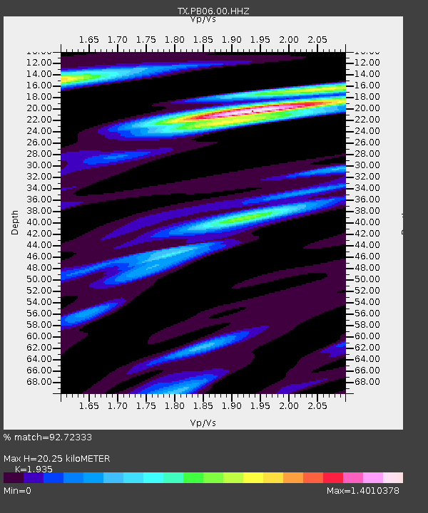
| Estimated Moho Depth: |
20.25 km |
| Estimated Crust Vp/Vs: |
1.93 |
| Assumed Crust Vp: |
6.121 km/s |
| Estimated Crust Vs: |
3.163 km/s |
| Estimated Crust Poisson's Ratio: |
0.32 |
|
| Radial Match: |
92.72333 % |
| Radial Bump: |
400 |
| Transverse Match: |
86.19694 % |
| Transverse Bump: |
400 |
| SOD ConfigId: |
2537391 |
| Insert Time: |
2018-01-28 09:24:27.496 +0000 |
| GWidth: |
2.5 |
| Max Bumps: |
400 |
| Tol: |
0.001 |
|
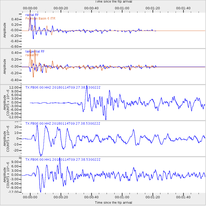
Signal To Noise
| Channel | StoN | STA | LTA |
| TX:PB06:00:HHZ:20180114T09:27:38.530022Z | 38.153645 | 8.191387E-6 | 2.1469474E-7 |
| TX:PB06:00:HH1:20180114T09:27:38.530022Z | 11.144789 | 2.104002E-6 | 1.8878796E-7 |
| TX:PB06:00:HH2:20180114T09:27:38.530022Z | 13.071044 | 2.2361892E-6 | 1.7107962E-7 |
| Arrivals |
| Ps | 3.2 SECOND |
| PpPs | 9.3 SECOND |
| PsPs/PpSs | 13 SECOND |


